Breaking news: a credible solution to the Bouvet Island lifeboat mystery has been found. See comments for 22-27 May 2011, 12 November 2011, 17-20 March & 9 April 2016, and 28 December 2023.
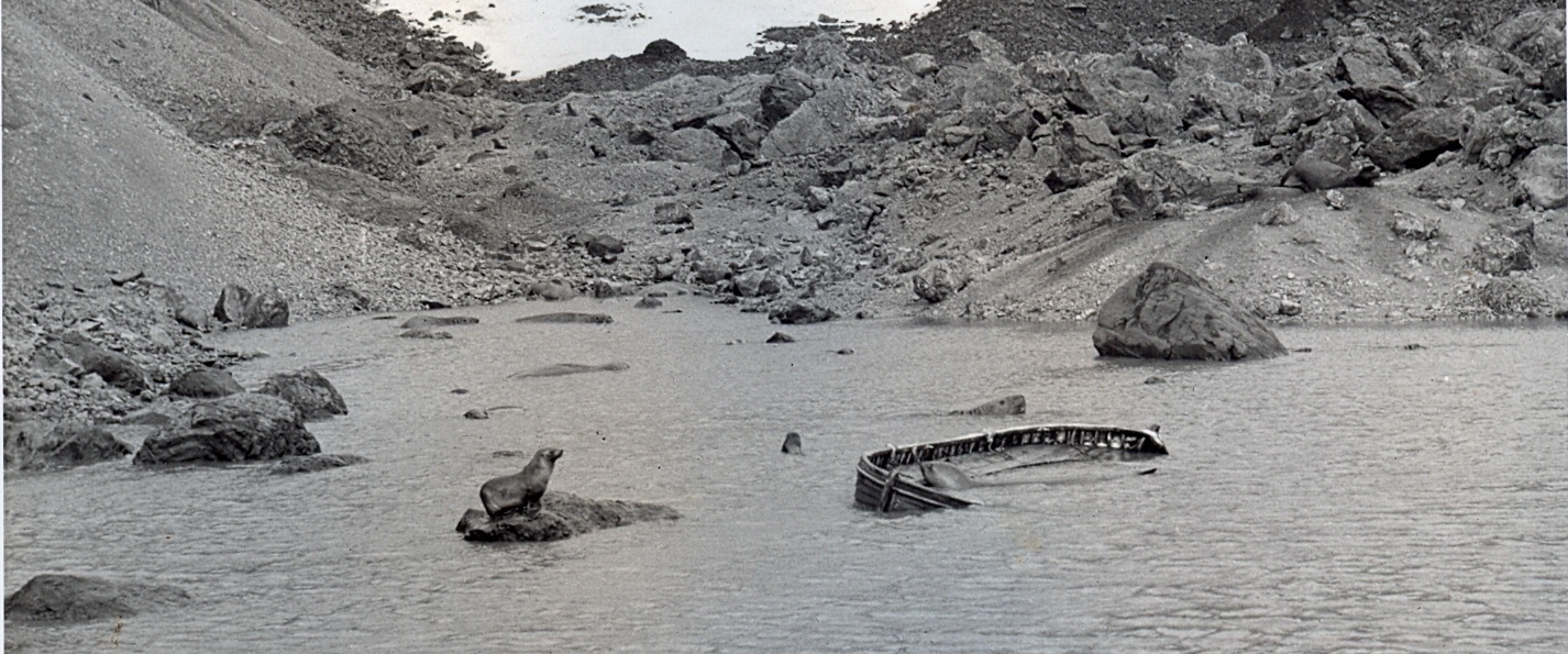
The unidentified whaler or ship’s lifeboat found abandoned on Bouvet Island on 2 April 1964
 There is no more forbidding place on earth.
Bouvet Island lies in the furthest reaches of the storm-wracked Southern Ocean, far south even of the Roaring Forties. It is a speck of ice in the middle of a freezing fastness: a few square miles of uninhabited volcanic basalt groaning under several hundred feet of glacier, scraped raw by gales, shrouded by drifts of sea-fog, and utterly devoid of trees, shelter, or landing places.
What it does have is a mystery.
Let us begin this tale at its beginning. Bouvet is appallingly isolated; the nearest land is the coast of Antarctica, a further 1,750km south, and it is slightly further than that to Cape Town and Tristan da Cunha. Indeed, as Rupert Gould put it in characteristic style:
It is the most isolated spot in the whole world – a fact which anyone who cares to spend an instructive five minutes with a pair of dividers and a good globe can easily verify. Around Bouvet Island, it is possible to draw a circle of one thousand miles radius (having an area of 3,146,000 square miles, or very nearly that of Europe) which contains no other land whatever. No other point of land on the earth’s surface has this peculiarity.
[Gould p.136]
Yet, for all this, the island has a rather interesting history. It was first discovered at a remarkably early date: on 1 January 1739, by the earliest of all polar explorers, the Frenchman Jean-Baptiste Bouvet de Lozier, after whom it is named. After that, however, the place remained lost for the next sixty-nine years – Bouvet had fixed its position incorrectly in an era in which navigation was still largely by dead reckoning. The island eluded the efforts of even Captain Cook to find it, and it only turned up again in 1808, when it was relocated several hundred miles from the spot where its discoverers had placed it. There remained considerable doubt, for the rest of the nineteenth century, as to whether the islands of 1739 and 1808 were even the same place, for not even the highly competent James Ross – in 1843 and again in 1845 – could locate Bouvet in the prevailing foul conditions, which include a semi-permanent shrouding of thick sea-mist, and storms 300 days a year. The isle was not fixed on the nautical charts until 1898, when it was definitively relocated by the splendidly-named Kapitan Krech of the German survey ship Valdivia. [Gould pp.138-46; Stommel pp.98-9]

Sea-cliffs on the north coast of Bouvet Island.
The Germans were the first to actually circumnavigate the island (Bouvet had believed that it was simply the northern cape of the sought-for Terra Australis, the gigantic but illusory southern continent it was long imagined must exist in the southern hemisphere in order to counterbalance Eurasia). They reported that it was no more than five miles long by three miles wide, that at least nine-tenths of it was under ice, and that it was almost entirely surrounded by unscalable ice cliffs which rose out of the sea well-nigh vertically to heights of up to 1,600 feet. [Muller et al p.260] But the Valdivia‘s men, like most explorers who make their way to this most inhospitable of places, found it impossible to land. Heavy seas, soaring cliffs, and the absence of any coves or inlets make it too dangerous to approach Bouvet Island by boat in any but the calmest weather.
The first explorers to actually make it ashore were Norwegians from the survey vessel Norvegia in 1927. Led by a worthy successor to Kapitan Krech, the equally alliterative Harald Horntvedt, they were also the first to venture onto Bouvet’s central plateau, which rises to about 2,500 feet (780m) above sea level and consists of a pair of glaciers covering the remains of a still-active volcano. Horntvedt took possession of the island in the name of King Haakon VII, renamed it Bouvetøya (which just means “Bouvet Island” in Norwegian), roughly mapped it, and left a small cache of provisions on shore for the benefit of any shipwrecked mariners. [Baker pp.72-3] The Norwegians returned in 1929 and again a few years later (when it was discovered that both their supply huts had been destroyed by the unremittingly hostile local weather), but after that Bouvet was left pretty much in peace until 1955, when the South African government expressed interest in the possibility of establishing a weather station there. To find out the answer to this question, the frigate Transvaal was sent south and she arrived off Bouvet on 30 January. [Crawford p.159]

Map of Bouvet Island as it is today. The Nyrøysa, where the mysterious lifeboat was discovered, can be seen on the north-west portion of the coast. Click to enlarge
It is here that the puzzle that concerns us comes gradually into focus. The South Africans sailed right around the island without finding any sign of the sort of large, flat platform on which a weather station might be built, but three years later – when the American icebreaker Westwind called at Bouvet on 1 January 1958 – it discovered that a small volcanic eruption had apparently taken place since 1955, and vented lava into the sea on the north-westernmost part of the island. The eruption had resulted in the formation of a low-lying lava plateau measuring perhaps 400 yards long by 200 yards wide. [Baker p.76; Crawford pp.162-4]
Bouvet Island had grown. And though the Norwegians, with a certain lack of poetry, named the plateau the Nyrøysa – meaning “New Mound” – they did so by scribbling the name onto their maps. No-one actually went all the way to Bouvet to investigate.
Fast forward six more years to 1964. The South Africans, who had finally got around to dispatching an expedition to take a look at the Nyrøysa, sent two vessels to rendezvous at Bouvet on Easter Sunday: their own supply ship R.S.A. and the Royal Navy’s Antarctic ice vessel HMS Protector. The expedition waited for three long days for the chill winds howling across the Nyrøysa to drop below their customary 50 knots (90 km/h; 57mph) until, on 2 April, it was finally judged safe to attempt a landing by helicopter. One of the Protector‘s pair of Westland Whirlwinds then dropped a survey team on the Nyrøysa. The man in charge was Lieutenant Commander Allan Crawford, a British-born veteran of the South Atlantic [Crawford pp.45-114], and it was he who made an unexpected find only a few moments after landing. There, wallowing in a small lagoon and guarded by a colony of fur seals, lay an abandoned boat: half-swamped, its gunwales awash, but still in good enough condition to be seaworthy.
What drama, we wondered, was attached to this strange discovery. There were no markings to identify its origin or nationality. On the rocks a hundred yards away was a forty-four gallon drum and a pair of oars, with pieces of wood and a copper flotation or buoyancy tank opened out flat for some purpose. Thinking castaways might have landed, we made a brief search but found no human remains.
[Crawford pp.182-3]

Geological map of the Nyrøysa by Peter Baker. The lifeboat was found in the larger and most northerly of the two small lagoons (shaded black) on the new lava platform. Click to enlarge
It was a mystery worthy of a Sherlock Holmes adventure. The boat, which Crawford described as “a whaler or ship’s lifeboat,” must have come from some larger ship. But no trade route ran within a thousand miles of Bouvet. If it really was a lifeboat, then, what ship had it come from? What spectacular feat of navigation had brought it across many miles of sea? How could it have survived a crossing of the Southern Ocean? There was no sign it had ever borne a mast and sail, or engine, but the solitary pair of oars that Crawford found would barely have been adequate to steer a heavy, 20-foot boat. Most unnervingly of all, what had become of the crew?
It’s unfortunate that the shore party had practically no time to investigate their peculiar discovery. They were on Bouvet for only a short while – about 45 minutes, according to Crawford – and in that time the men had to conduct a survey of the platform, collect rock samples and fend off the attentions of aggressive male sea-elephants who resented their intrusion. There was no time to explore the Nyrøysa properly or to hunt for any further signs of life. Given those constraints, it is very unlikely that the “brief search” Crawford mentioned consisted of much more than walking a few yards from the lagoon in either direction and scouting for the most obvious signs of bodies or habitation. Nor does it appear that any subsequent visitors to the island continued the investigation. There is, in fact, no further mention of the mysterious boat, though Bouvet was visited again two years later, in 1966, by a biological survey team whose members paid considerable attention to the lagoon. This group established that it was shallow, thick with algae, alkaline – thanks to seal excreta – and fed by meltwater from the surrounding cliffs. [Muller et al p.262] But if the lifeboat was still there, they did not mention it.
In fact, nobody but Allan Crawford seems to have taken the least interest in the mystery. There was no contemporary newspaper coverage of the story, nor have I been able to find any further details of the boat itself, nor of the items found on shore. One or two further brief contemporary accounts of the landing do exist, apparently, but in a publication so obscure that I have not so far found copies of it.¹ No one, in short, seems to have asked how the boat came to be there; no one searched for any members of its crew. And no one attempted to explain what Crawford found.
Pretty much all we have to go on, then, are a few scant lines of Crawford’s, a sketchy knowledge of Bouvet Island’s history, and some common sense conclusions regarding the likely behaviour of shipwrecked mariners. With these, nonetheless, it is possible to construct at least three possible hypotheses that might explain the presence of the whaler.
We’ll begin by setting out the facts we can establish. First, it is clear that the boat must have arrived on Bouvet at some point in the nine years between January 1955, when the Nyrøysa did not exist, and April 1964, when it did. That is a reasonably restricted timeframe, and if the whaler really was a lifeboat, it ought to be possible to establish which ship it came from. Second, the Protector‘s shore party saw no sign of any camp or shelter, fire or food. Third, the presence of a heavy boat in a lagoon located at least 30 yards from the shore suggests either that it reached the island with a full crew, enough to man-haul it over some pretty rough ground, or that it was put there by a smaller group who didn’t plan to leave the island for some time. Beyond that, though, all is speculation – and perhaps the strangest thing about this extremely strange incident is that the handful of facts we have don’t fully support any of the obvious theories.
Let’s look first at the possibility that the boat was what it appeared to be: a lifeboat from a shipwreck. That would certainly be the most dramatic and romantic explanation, and it explains some of the things that Crawford noted: why the whaler was in the lagoon (it was put there by men who had no way of tying it up securely on shore, and who weren’t certain if they would need it again) and why a small pile of equipment was found close by. Who knows why Crawford’s “copper flotation or buoyancy tank” had been “opened out flat” – but it sounds like the sort of thing a group of desperate men with very limited resources might do. The lifeboat theory probably also offers the best explanation for the presence of only a single pair of oars on shore: perhaps there had originally been others, but they were lost overboard in the course of a terrible voyage.
There are, however, plenty of things that don’t fit the lifeboat hypothesis, and the most obvious is the lack of much equipment and the absence of either bodies or a camp. There would be no good reason for a group of survivors to move away from the Nyrøysa; it is clear of snow, at least during the southern summer, and is the only large, flat area of ground on the entire island. But if a party of survivors did stay put in this small area, and died there, then some trace of a campsite, not to mention signs of their bodies, ought to have been discovered in even the most hasty search.
Might a small group have moved on and died elsewhere on the island, though? Unlikely. Bouvet’s ice cliffs are high and highly prone to avalanche, so it would be very dangerous to attempt to move inland or to camp too close to any of the vertiginous rock faces that abound on the island. On top of that, the most obvious sources of food – Bouvet’s seals and sea-elephants – congregate on the Nyrøysa. There would be no real need to hunt elsewhere, unless the survivors had been on the island for so long that they had wiped out the local animal population – and if that was the case, signs of a campsite ought to have been doubly obvious. The men would surely have left the remains of fires and sea-elephant suppers.
Just how likely is it, anyway, that any group of shipwrecked seamen would have made their way to Bouvet? Not only is the island remarkably hard to locate in even the best of circumstances; it also lies so far off the normal trade routes, and is so notoriously barren, that it’s hard to imagine any group of men with any alternative would have made for it in any but the most desperate of circumstances. Only a ship that went down to the west of Bouvet (so that the prevailing currents would have swept lifeboats towards the island), and which did so within a few hundred miles of it, at most, would be a likely candidate, and any hypothetical wreck would certainly require that a competent navigator equipped with charts, instruments and a huge degree of fortune was among the unhappy survivors. If the men in the lifeboat had had time to find their charts and sextants, however, they ought to have had time to have brought a good deal more equipment with them than Crawford discovered on the island. What sort of castaways, after all, make it to shore armed with nothing more than a barrel of water, a pair of oars, and an empty copper tank?

Stranded on Elephant Island, Ernest Shackleton’s men construct a shelter from a pair of boats, 1916. They survived in this accommodation for more than four months
Finally – and to my mind most significantly of all – why would any party of survivors, however well equipped, have left their boat floating in the lagoon? It was the only readily available source of shelter that they had on an island where, even in summer, the mean temperature hovers around zero. When one remembers what Ernest Shackleton’s men did when they were stranded on Elephant Island a few years earlier (they upended their boats and turned them into living quarters), it has to be admitted that the discovery of the boat in the lagoon is perhaps the strongest evidence that wherever the whaler came from, it was not the sole survivor of some grisly shipwreck.
What, then, of other explanations? Less likely, but not altogether impossible, is the suggestion that the boat found its way to Bouvet without any men on board. It might have been lost during a shipwreck, overturned and ditched its crew, or simply been washed overboard in a storm, and then drifted about the Southern Ocean, perhaps for years, before being washed up on the island. This theory has the virtue of simplicity, and it certainly explains why the boat appeared so worn – “there were no markings,” remember, “to identify its origin or nationality” – not to mention the absence of any signs of life on shore.
Other than that, though, the “derelict” hypothesis has little to recommend it. It certainly does not explain why Crawford found equipment left on shore, and it frankly strains credulity to suggest that, after making an ocean voyage of hundreds, perhaps thousands, of miles, a waterlogged hulk was washed ashore (in a storm presumably) in such a way that it avoided being dashed to pieces against Bouvet’s cliffs, was left pretty much undamaged, and then came to rest in the one spot on the coast of a small and remote island where it would not have been washed back out to sea again. It’s not as if that part of the island’s coast is knee deep in flotsam and jetsam, either; the men of the 1966 biological survey noted “the absence of practically any washed-up marine life this exposed western side of the island.” [Muller et al p.262]
A landing party from the Transvaal goes ashore on the east coast of Bouvet Island, January 1955. The man in the officer’s cap is Allan Crawford, who discovered the abandoned lifeboat on the far side of the island nine years later
A third possibility is that the boat might have come from an unknown ship that called at Bouvet between 1955 and 1964, and was, for some reason, abandoned there. This suggestion most convincingly explains the presence of the whaler; it is precisely the sort of general purpose craft used to make a landing, and in fact the Transvaal, when she called at Bouvet in 1955, had put her men briefly ashore in a very similar craft. If the abandoned boat had reached the island on a ship, moreover, there would have been no need for any implausible feat of navigation by its crew – and be in no doubt that a long voyage across the Southern Ocean in an open boat certainly is implausible, given the prevailing weather conditions. Ernest Shackleton’s voyage from Elephant Island to South Georgia, across 800 miles of the same seas, is routinely lauded as one of the greatest of all feats of seamanship, after all – and it was accomplished by men who were properly supplied, fully equipped, and who sailed, moreover, in an enclosed boat provided with a deck casing that prevented waves from slopping onboard.
The suggestion that the abandoned boat had belonged to a landing party has another advantage: it explains the absence of bodies, a campsite and significant quantities of equipment. Suppose, for example, that a group of men made a landing in two boats, but left the island in one, taking their gear (and any bodies, I suppose) with them when they went. Or perhaps they landed in the boat, and were later evacuated by helicopter. If the landing had taken place during the 1950s, moreover, it doesn’t seem all that unlikely that five or six harsh Bouvet Island winters would have been sufficient to erase any names or other markings that the boat once had.
Yet even this explanation, attractive though it is, has substantial holes in it. What sort of expedition would be planning to stay so long on the island that its men would go to the trouble of man-hauling a big boat into the lagoon – Crawford’s team, after all, did what they needed to do in less than an hour? What sort of expedition goes ashore carrying a copper flotation tank? And what sort of expedition would be so poorly equipped that it was forced to improvise, while briefly on shore, by hammering flat said tank?
Indeed, the more one tries to think through this superficially attractive solution to the problem, the more questions it raises. Perhaps the most important one is this: why would any shore party abandon such a valuable boat when they left? Whalers are pretty expensive items, and need to be accounted for. Yes, one might suggest that the boat had to be left because of some sort of emergency – but if the weather was so bad that there was no possibility of launching it again, it would surely have also been too bad for any shore party to get off in a second boat, or to be evacuated by helicopter. And if one imagines, say, an accident that required the immediate heli-borne evacuation of an injured man – leaving not enough men ashore to handle the boat – why would the party have taken all their usable equipment with them, but left a single pair of oars? Why not go back later for the oars and the whaler? Why, indeed – if there was a helicopter available all along – land by boat in the first place?
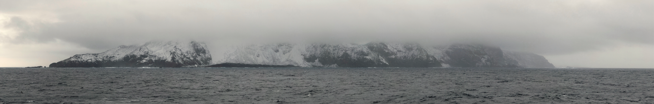
Bouvet Island: “A speck of ice in the middle of a freezing fastness: a few square miles of uninhabited volcanic basalt groaning under several hundred feet of glacier, scraped raw by gales, shrouded by drifts of sea-fog, and utterly devoid of trees, shelter, or landing places.” Photo: François Guerraz. [Click to see full size]
One other obvious area for additional research remains, and that is to look into who else might possibly have been on Bouvet between 1955 and 1964. At first glance it appears unlikely that any such unknown expeditions ever took place – the island, after all, commonly went years without seeing human beings. But in fact traces of at least two possible visits do exist, and – in theory, at least – either might have abandoned a whaler in the lagoon.
The first, and by a distance the least likely, is also the most mysterious, for when Allan Crawford was working in Cape Town in May 1959, he received a visit from an Italian calling himself Count Major Giorgio Costanzo Beccaria, who asked his advice about chartering a ship to go to Bouvet. The Count’s purpose, it was explained, was to help a Professor Silvio Zavatti go ashore on the island to conduct scientific research.
Crawford did what he could to help the Italian locate a suitable vessel, but without success, and the Count returned to Italy. In June 1960, though, Crawford received an odd letter from Professor Zavatti himself in which he claimed not only to have gone to Bouvet, but to have ventured ashore, landing in March 1959.
The letter took Crawford by surprise, since he knew of no ship in any South African port that the Italians could have chartered, and when he wrote to Costanzo he received a letter denying an expedition as described had ever taken place. Zavatti, however, supplied further details, and even published a book, Viaggo All ‘Isola Bouvet, in which he described his adventures. This volume, Crawford drily notes, was written for children and illustrated by only a single photograph – “of seals, which could have been taken in any zoo” – and he eventually concluded that the entire episode was a hoax. [Crawford pp.172-6] If the Zavetti expedition did take place, moreover, there is nothing in any of Crawford’s evidence to suggest that it abandoned a whaler on the island.
Altogether more promising, however, is a brief reference to another visit that I turned up in a bibliography of scientific research on Bouvet Island. [Watkins et al] This suggests that in 1959 – five years before the South Africans arrived, which certainly fits well with Crawford’s observation of a worn and scoured-clean whaler bearing no identifying marks – a Soviet expedition including one G.A. Solyanik made some ornithological observations on Bouvet Island. That much, at least, is certainly implied by the title of Solyanik’s paper (which I have not yet seen), since it is called “Some bird observations on Bouvet Island.” It appeared in the second volume of a regrettably hard-to-find journal called the Soviet Antarctic Expedition Information Bulletin, published in 1964.

The Soviet icebreaker Ob’ in the Antarctic, c.1958
A brief poke about online confirms that Solyanik was real enough – he was a researcher at the Odessa Biological Station – and that he took part in the four-year First Soviet Antarctic Expedition (1955-58), organised to coincide with the International Geophysical Year of 1957. This expedition sailed on board the icebreaker Ob’, which was certainly large enough to carry whalers, and rendezvoused with a pair of Russian whaling ships, the Slava and the Ivan Nosenko, establishing two shore stations in Antarctica. Like the likely-mythical Italian expedition to Bouvet, the timing looks about right to account for a weatherbeaten whaler, left over from the visit, to have been found without identifying marks six or eight years later. And, given the secrecy that attached to most things the Soviets attempted at the height of the Cold War, it would not be much of a surprise to find that they did a lot of things in the Antarctic that the British and South Africans were unaware of at the time.
This is all still fantastically hypothetical. Further research is needed here. The Soviet theory certainly doesn’t answer all the questions I posed earlier in this post, and it’s not yet at all clear to me whether the Russians really did go ashore on Bouvet Island – and, if they did, whether some mishap resulted in them abandoning equipment there. Put a gun to my head right now, however, and I’d suggest that the most likely explanation for Allan Crawford’s mysterious discovery of 2 April 1964 may lie in the memories of some ageing Russian ornithologists, or in a long-forgotten audit of equipment supplied to the icebreaker Ob’, lying in some obscure ex-Soviet archive.
1. The Newsletter of the South African Weather Bureau.

Sources
P.E. Baker. ‘Historical and geological notes on Bouvetoya.’ British Antarctic Survey Bulletin 13 (1967).
Allan Crawford. Tristan da Cunha and the Roaring Forties. Edinburgh: Charles Skilton, 1982.
Rupert Gould. ‘The Auroras, and Other Doubtful Islands.’ In Oddities: A Book of Unexplained Facts. London: Geoffrey Bles, 1944.
Charles Hocking. Dictionary of Disasters at Sea During the Age of Steam, Including Sailing Ships and Ships of War Lost in Action, 1824-1962. London: London Stamp Exchange, 1989.
Norman Hooke. Maritime casualties, 1963-1996. London: Lloyd’s of London Press, 1997.
D.B. Muller, F.R. Schoeman and E.M. Van Zinderen Bakker Sr. ‘Some notes on a biological reconnaissance of Bouvetøya (Antarctic)’. South African Journal of Science, June 1967.
Henry Stommel. Lost Islands: The Story of Islands That Have Vanished from the Nautical Charts. Victoria [BC]: University of British Columbia Pess, 1984.
EM Van Zinderen Bakker. ‘The South African biological and geological survey of the Marion and Prince Edward Islands and the meteorological expedition to Bouvet Island.’ South African Journal of Science 63 (1967).
BP Watkins et al. ‘Scientific research at Bouvet Island, 1785-1983: a bibliography.’ South African Journal of Antarctic Research 25 (1984).

* Remote, decolate location? Check
* Sheer cliff walls? Check
* Hundreds of feet of glacier deep? Check
* Constantly shrouded by mist? Check
* Active Volcano? Check
Well that’s it. I have found my evil genius lair.
Came here to do the whole L O S T thing, but this is much better. Good show!
Pretty obvious, this is the island from “Lost.” Must be the life boat the polar bear used to get to the island.
The CIA was going to attack your glacier-fortress and arrest you for being evil, but then some intern in the 40s had the brilliant idea of morphing the US economy to become highly dependent on carbon-emissions, thus causing global warming and melting your ice fortress.
If you are thinking about building somewhere to stay permanently, why not go with the Kerguelen Islands there may be a few pesky civilians on the island already, but it comes free with satellite and missile tracking stations, and the weather is about 20 degrees warmer all year round.
If you fancy somewhere more tropical why not Manuae) you could excavate the volcano and live in a tropical paradise!
I called it First!
Found your page while researching Bouvit for a piece on unbelievable islands I was writing. There is more detail here than in any other webpage I found. I agree with the idea it was the Soviets – no other explanation makes sense.
Perhaps this has already been suggested somewhere in the hundreds of comments that precede mine.
I don’t think the lifeboat/whaleboat was hauled over the patch of land, Nyroysa, that was created sometime between 1955 and 1958. The geological map in the article indicates that part of Nyroysa where the boat was found is sand. My guess is that when Nyroysa was initially formed, it consisted only of the areas denoted as rock. To the north and south of the newly formed rocky area, were embayments where sand began to deposit. The northern embayment , filled in with sand, is where the boat was found. The boat arrived fairly early in the filling-in of that embayment; more sand was deposited after the boat arrived, and so by the time the boat was found in 1964 the boat was about 200 meters from the shoreline.
To clarify, when I said “My guess is that when Nyroysa was initially formed, it consisted only of the areas denoted as rock” I was alluding to the Peter Baker map of Nyroysa found in the above article.
For me the strong possibility is that a crew member on a passing ship, came down with a unknown and scary disease (leprosy?)…and the crew members left him adrift. Near death, he did nothing to sustain himself thus nothing showing he was actually there. Bones an flesh eaten and clothing blown away. No trace.
Is it really that impractical for a small boat to wash up on an island after being lost at sea?
No, but… the points made are [i] it’d be an amazing coincidence for a small boat to end up 30 yards inland in a lagoon – the one place on the coast of the island where it wouldn’t be washed straight back out to sea; [ii] that it’d be even more amazing that the boat remained in good condition, rather than, say, being smashed to bits on the rocks – and [iii] even if all that did happen, it doesn’t explain the scraps of equipment laid out on the shore nearby.
Surely it makes perfect sense that it would be found in the one place where it wouldn’t be washed back out to see – it’s already been to all the other places and been washed back out again.
Without incurring any damage??
Wouldn’t being swept up against cliffs like this island has have smashed the boat to matchwood?
Wait, so god isn’t real? ;P
It’s the most remote island in the world. You can draw a circle with a 1,000 mile radius around it (containing an area the size of Europe). Read the article. It puts it much more eloquently than I can in regards to the theory of it just washing on shore.
“Frankly it strains credulity to suggest that, after making an ocean voyage of hundreds, perhaps thousands, of miles, a waterlogged hull was washed ashore (in a storm presumably) in such a way that it avoided being dashed to pieces against Bouvet’s cliffs, was left pretty much undamaged, and then came to rest in the one spot on the coast of a small and remote island where it would not have been washed back out to sea again. It’s not as if that part of the island’s coast is knee deep in flotsam and jetsam, either; the men of the 1966 biological survey noted “the absence of practically any washed-up marine life this exposed western side of the island.” [Muller et al p.262]
Yeah… It is if its 1600 km from the nearest island…
it seams like the only mystery, as even the writter admits to, is that they can not find anyone with enough free time to read some records and find out whats going on.
Perhaps someone should tell 4chan that the boat is a 14 year old girl.
would any remains, or supplys have been eaten or taken by the seals and used in a nest or something (keybord has no question mark)
Man always leave to much junk behind bones, fire pits. shelters.as mention when your shipwrecked you drag the boat up onto shore and flip it for shelter the boat was not found this way. Also all sea going vessels have names and any boat on the ship is named after that. well before 1200 A.D. this boat had no marking that’s part of the mystery.
It’s like rainbows and magnets, man.
Jacob
How’d Jacob get there? Tide goes in, tide goes out. There’s a life boat. How’d that get there? You can’t explain that. Never a miscommunication. The lifeboat is now diamonds.
Fascinating! 100 up boats for you.
It’s like double rainbows and magnets, man.
FTFY
i thought the same thing, in addition to the repeated mention of how bad the weather is there, it seems a few years could erase any traces of shipwreckees.
I’m guessing yes to the seals eating stuff, but even so, if it was a lifeboat there’s still the mystery of what ship would be so far away from the normal sea lanes and how it made it to such a small island in such rough seas. The abandoned-by-the-Russkies explanations seems to fit much better
Things not to change on your blog
~ The template and presentation… are just great as they are.
~ The content is amazingly rich and should stay that way.
~ The subjects are carefully selected and researched – what else could we ask for?
Thanks and hope to see you rising to further victories.
You can’t explain that. – Bill O’Reilly
Wasn’t there a question on Jeopardy relating to this island last week? A Nat Geo sponsored series of questions?
LOST
You can’t explain that!
polar bears
boat on island far away from shit; where did it come from? news at 11
Lmao
Can’t explain it? Must be God.
Lava ate them?
Wonderfully researched article
How was the boat found if it was in “the most isolated spot in the world”?
Did you actually read the article?
+1 ^
Clicking link after link, this story took my whole evening.
this article = tldr
There is an abandoned lifeboat and some equipment on a very remote island. Nobody knows how it got there, what happened to whomever brought it there, or when it all happened (although that is narrowed down to within a few years – within the late 50’s to early 60’s). Picture the island from Lost, but in an antarctic setting.
That’s a really brief tl;dr, though. The article is worth looking over when you have the time. It’s interesting and a little creepy to think about someone on such a remote place and to wonder what they were doing there.
Some people used to read these things called books, y’know… Back when I was a boy.
Huh? U mean they used 2 carry those heavy computer monitors and towerz with them instead of a kindle. Lolz!
maybe it was someone from the titanics boat..perhaps jack survived after all
solved: avalanche. they said it was pretty dangerous. guys probably got off ship, o shit an island! walk around for a few hours, AWE FUCK SNOWWW and bam.
Ehh.. Could it have been abandoned by one of the earlier sailors?
Although it would only explain the fact that it has no markings or a ship name on it, as it wasn’t so accustomed at the time, it seems nearly impossible. First of all it was found on a the part of the island that was created merely 65 years ago. Also 100 – 150 years -especially in that island- would be more than enough to completely destroy the boat or at least bury it deep down. Besides ignoring all of the above, the exploring ships that are mentioned were neither big enough nor designed to carry a boat of such size. After all, everything aside, none of the Captains’ logs of said previous explorers mentions loss of a boat or some sort of arrival in the island. I too support the Ruskie Hypothesis and I’m going to make some research. I hope that covers your question 🙂
Is there a chance that the boat was part of the provisions the Norwegians left on the island? I mean it makes sense…if you’re going to leave food and such for someone who is shipwrecked, might as well also leave a small boat so they can get away.
That doesn’t make sense because, according to the article, the nearest land (Antarctica) is 1,750km away. Habitable land is even farther away than that. There is no way a 20-ft rowboat could make that trip.
Understandable, but this seems like a situations where if you’re going to leave someone food, might as well leave them a boat. The provisions could only sustain someone for so long.
“Well, you guys will probably die before you can row 1,750km to Antarctica–where if you’re not dead yet you will be soon enough–so here’s a boat if you ever fancy escaping when you finally reach suicidal levels of desperation.”
I love reading about this kind of stuff, just fascinating.
looks like Frankenstein made it to the wrong Pole..
A long-ish read (in internet terms), but I found it interesting.
“long” geez it’s just an article, and a well written and interesting one that should hold anyone’s attention to the end. Where do you get “too long”?
Nah man, see:
“The first explorers to actually make it ashore were Norwegians from the survey vessel Norvegia in 1927. Led by a worthy successor to Kapitan Krech […] and left a small cache of provisions on shore for the benefit of any shipwrecked mariners.”
The lagoon where the boat was found is located on a lava plateau didn’t exist until at least 28 years later:
“on 1 January 1958 – it discovered that a small volcanic eruption had apparently taken place since 1955, and vented lava into the sea on the north-westernmost part of the island. The eruption had resulted in the formation of a low-lying lava plateau”
Ah, thank you. I had read the majority of the article, I should have put two and two together. It remains a mystery.
Here’s the GMaps link:
http://maps.google.com/?ie=UTF8&ll=-54.428118,3.409367&spn=0.084082,0.222988&z=13
Zoom out. Zoom out. Zoom out. Zoom out. Zoom out.
Wow. Yeah that is quite isolated.
No streetview D=
Step 1: Alt + 63 (on numpad) Step 2: ?????? Step 3: If you were able to type step 2, then profit?
For some reason, I have an almost aspie level fascination with Bouvet Island, this perfectly remote and desolate place, but because it’s actually not that interesting from a historical standpoint there’s very little written about it. It’s like having an itch that can never be scratched.
Still, the second thing I’ll do when I’m a millionaire is charter a ship with a helicopter to take me their for a couple of days.
The first is two chicks right?
I share your aspie-level fascination. I’ll go halves with you on the helicopter.
Dont be hard on yourself; there’s something compelling about incredibly remote places, the moreso in our inter-connected modern world. I find your fascination quite understandable. I hope you someday get there (but not by whale boat!)
I guess its not so isolated. I think our understanding of Bouvet Island should change.
The writer has answered the question of who to my satisfaction, it seems it is very plausible that it was the soviets. As for why the boat and oars were left with no evidence of any supplies or habitation, my theory is that multiple boats were sent to the island, at least one person got lost and so one boat was left in case they found their way back in time.
Anyway, it was a pretty interesting read.
DYK that Bouvet Island, despite being completely uninhabited, has it’s own top-level domain: .bv
http://en.wikipedia.org/wiki/.bv
I saw this too, and was simply in awe. Dunno why anyone thought that would eve be needed.
Actually, maybe the guys from The Pirate Bay could purchase it 😛
the REAL mystery is why your keyboard doesn’t have a question mark
Drunk guy.
Stole the boat.
Wandered off.
What do I win?
Day 86: Horror…death stalks us constantly now..have consumed the dead. Only 5 of us remain from the original 25. The “survivors”, if we can be called such, are less human and more monstrous..sunken, glassy, black eyes…When our whaling ship was sunk by a breaching whale with a harpoon stuck in its hide, we were forced to abondon not only much of our stock, but our hope as well.
Day 87: What’s this?! Oh, joy and rapture! Thar be an island ahead! What manner of paradise has finally been bestowed upon us?! Oy, I knew if we just stayed alive there would be a boon in store! I cannot wait to reach the shores of what no doubt should be a tropical paradise.
I took the time today to read over lunch your story on Bouvet, and that reminded me I had been planning to look up a book by Gerrit Jan Zwier in which he describes his visit to Bouvet, so I ordered that before I could forget again. Secondly, I also searched for professor Zavatti – mainly because that count was probably a real count. Beccaria was the name of the man responsible for making the Grand Duchy of Tuscany in 1786 the first European country to abolish the death penalty. It turns out, according to Italian Wikipedia, that Silvio Zavatti existed, and the entry also confirms the man went to Bouvet (or confirmed that he claimed he did). Moreover, he appears to have been a genuine polar explorer, and founder of the Museo Polare in Fermo, a coastal town on the Adriatic, in the region called the Marche (see http://www.museopolare.it/, regrettably mostly in Italian). There is also an English page, in which somewaht more is said of Zavatti’s attempt to found a base on Bouvet (http://www.museopolare.it/English.htm; at times the English is fairly bad).
This does not mean obviously that the man did not commit a fraud, though while looking for Internet traces of Beccaria I came across this on Google Books:
http://books.google.nl/books?id=Sg49AAAAIAAJ&pg=PA386&lpg=PA386&dq=%22Giorgio+Costanzo+Beccaria%22&source=bl&ots=4biMGq4Dp8&sig=wHmy8-Bl8wcT6q4OronJRCILAlg&hl=nl&ei=GhdZTei4BMGAOovWtbEF&sa=X&oi=book_result&ct=result&resnum=2&ved=0CCMQ6AEwAQ#v=onepage&q=%22Giorgio%20Costanzo%20Beccaria%22&f=false.
There actually the hired whaler is named.
Possibly there is something in it – then again, maybe not. You might have to go to Italy on a holiday to find out more, 😉
Thanks, Henk.
Crawford did mention somewhere in his book that Zavatti named the ship he hired, and he checked out the claim with the owners, who said she had been in port in South Africa the whole time he claimed to have been onboard!
I can’t find Nyrosa, it’s supposed to be flat and low-lying right? I can only see cliffs bordered with ice.
Edit: Used google earth’s 3d function to look at it from the ocean’s view. Seems like this is the flattest area, http://maps.google.com/?ie=UTF8&t=h&ecpose=-54.40795396,3.2613412,731.85,99.467,67.195,0.028&ll=-54.409172,3.290802&spn=0.005014,0.016512&z=17 can’t see any lagoons though.
The vikings!
For some reason this reminded me of a side story in a Thomas Pynchon novel.
Mayhaps a lost boat was placed there by an unrecorded tsunami and the other traces were made by later visitors.
Pingback: Top Posts — WordPress.com
Looking at the 3D google link a few posts above and the Geological Drawing from the article; it appears the Nyrosa has already eroded into the sea a 100 m or more since the time of the drawing. Therefore the lagoon may no longer exist as i would be right on the current shoreline.
i love stuff like that but far too much to read lol
Giorgio (first name) Costanzo Beccaria (family name) was, as it seem, an explorer, even if he is known for exploring the Piaroas in Venezuela. He was born in Rome August 15 1914 and either the Museo Polare doesn’t update its site often or he’s still alive. Both Beccaria and Costanzo were families registered in the Nobility book for the Kingdom of Naples.
Crawford, by the way doesn’t insinuate that the man was ‘calling himself’ anything. “An Italian, Count Major Giorgio Costanzo Beccaria, came to my office in Cape Town with a presentation letter”. On the other hand someone told him what the book was about since he ‘cannot read Italian’.
The Italian project was about extablishing an Italian base for further explorations. Aptly named ‘Progetto Cenerentola’, Cinderella Project, fell through for general disinterest and lack of founds.
They went to Bouvet with a whaler whose captain lent them a boat, or rather as Zavatti calls it a dinghy, to land.
By the way the Italian expedition made two landing. One on Lars Island nearby – just like Harald Horntvedt – where they were stranded two days because of bad weather and a second one ‘on a little bay just south Cape Norway’. They were on Bouvet a few hours only, and in the wrong place anyway. There’s a long excerpt of the book here: http://www.ariannaeditrice.it/articolo.php?id_articolo=16037 for those who do read Italian or use Google Translator. Its stop just when they land on Bouvet 😦 .
Even through Google Translator it should be evident that the ‘book’ – 79 pages only – is aimed at children, very much in the adventure book style. A more scientific report was published on magazines:
ZAVATTI, Silvio, Verso l’isola Bouvet avamposto del Polo, in Paese Sera, Roma, 7 maggio 1959; La missione antartica italiana, in Le vie del mare, Milano, sett. 1959; L’Italia si è affacciata per la prima volta all’Antartide, in L’Universo, Firenze, sett.-ott. 1959; La missione italiana all’isola Bouvet, in Collectors’ Post, Milano, sett.-dic. 1959; Ritorno della missione antartica italiana, in Le vie del mare, Milano, febbraio 1960; La Missione Antartica Italiana all’isola Bouvet, in Rivista aeronautica, Roma, nr. 2, 3, 4 del 1960.
As for the mystery boat, could it be that someone came on the island on two boats and some incident incapacitated enough men that they couldn’t man both anymore, and were forced to leave one on the island (with the useless pair of oars)? They pulled it as far from the beach s they could hoping to come bach and fetch it, but the weather didn’t allow them. The flattened tank puzzles me, however. Unless they tried to patch some hole?
Thanks, Silvia. That’s extremely useful information, and I’m sorry to have sounded so sceptical about poor old Count Costanzo.
It’s worth noting, though, that the Count himself was very sceptical of Prof. Zavatti’s claims. According to Crawford, “he could not credit that his colleague could have stretched his imagination so far! I asked for an explanation. Zavatti, he said, had been so keen to form this expedition, and the Italian authorities had been so reluctant to support it, that he had felt the only course open to him was to pretend that a pilot visit had already taken place so that the Government would feel it was financing a viable project.” [p.174]
Crawford also notes that some years later, in 1978/9, he got the librarian at the Scott Polar Research Institute in Cambridge to write to Italy and ask Prof. Zavetti for the name of the vessel he had travelled to Bouvet Island on at the time of his expedition – late March 1959. He received a reply naming her as the whale catcher “Setter IV”.
“Upon hearing this,” writes Crawford, “I considered I held a trump card, as I had known the “Setter IV” quite well. I asked the Port Captain of Cape Town to let me know the movements of this vessel 20 years before.
“”We have established from harbour pilot logbooks,” he wrote in reply, “that “Setter IV” docked at M berth on 20 March 1959 and shifted to the Robinson Dry Dock on 3 April. The vessel is recorded next as having sailed from M berth on 15 December 1959. It can be seen from the above that it is extremely unlikely that “Setter IV” was at Bouvet Island on 22nd and 23rd March 1959.”” [Crawford pp.175-6] The voyage from Cape Town to Bouvet takes about five days, so Crawford seems to be correct.
On a more positive note, I find your theory as to how the abandoned boat got into the lagoon to be quite convincing. One could easily imagine a siutation in which rough weather made it impractical to try to get off the island with the mysterious oars, and they would not have been valuable enough to be a consideration in such circumstances.
The flattened copper was an attempt to fashion a rudamentary reflector to use the sun to signal distant ships.
Mmmkay. I was thinking about this. What about possible penal colony ‘inmates’, who might have been savvy enough to fashion an attempted escape, only to end up on the island, meeting a hasty demise? Ok. It’s waaay far-fetched, indeed. But Ive read a handful of books about various penal colonies of different countries…France, Russia, etc. My point, I guess, is, if, in any penal system, there are at least one or two amongst the prisoners who try (sometimes successfully) escaping, what if…Okey dokey. I think you get my drift. Haha..’drift’ 🙂 MS/LT (ps/a good read is “Hell Beyond The Seas”, by Krarup-Nielsen, Aage, about the French Penal Colonies, and a man who escaped. I doubt anyone from the French Penal Settlement in Guiana would have made it all the way to Bouvet Island, but what about an escapee from a different country, whose penal settlement was located not so impossibly far away? The copper tank, well, that is a curiosity, too. Just a thought…)
Thanks, Maggie. As a matter of fact, a short series on some of the more notable escapes from the penal colony in French Guinea (popularly known as Devil’s Island) is planned for later in the year.
From the perspective of your suggestion, it is as you say unlikely – the French did have another penal colony in New Caledonia in the Pacific, but my view, given the prevailing conditions, is that even if a group of escapees in the sort of open boat discovered in the lagoon had wanted to go to Bouvet and known how to get there, they couldn’t have expected to survive a long ocean voyage without being swamped. Wherever it came from, the boat must have begun its journey to the island from reasonably near by.
Thank you for your further researches!
*that he had felt the only course open to him was to pretend that a pilot visit had already taken place so that the Government would feel it was financing a viable project*
In fact the Govenment wasn’t that all helpful. Zavatti ended financing his own expedition, which made for a strange voyage (Genua to Mogadiscio on a banana carrier, Mogadiscio to Durban with a cargo steamer, Durban to Porth Elizabeth then to Cape Town by plane) which might explain why it was so hard for Crawford to trace him.
From the summary I have, they found a whaler that was in train of joining others and the captain agreed to take the explorers there and retrieve them on its journey back – which seems to me mightily risky, but whatever.
Anyway I wrote to Museo Polare in hope to solve this puzzle…
As for the main mistery: how often did expeditions land on Lars Island and not straight on Bouvet? from there they could travel by boat to Bouvet and hopefully paddle back, leaving on Lars the main equipment. Also, how dangerous those male sea lions could be? Enough to put a boat out of commission, or to kill everyone who disembarked?
Very good work, but in this case, I think you eliminate too many theories due to using otherwise sound logic that might not be possessed by a stranded crew member. For example, the occupants of the boat might not have known the island was uninhabited and chose to look for a settlement soon after landing. Perhaps they were looking for a weather or navigation station that they could disrupt in order to attract a repair crew. Even climbing a peak to signal passing ships might have seemed like a good idea. Searching for provisions or finding a cave or campsite without elephant seals might also be a motive for abandoning their landing spot. Although we know better, it is easy to imagine someone thinking that there has to be a better place on the island to survive than the landing site.
It is also possible that they attempted, unsuccessfully to tie up the boat, or that tides removed it from a previously secure position. I would imagine that if someone were lost at sea for a time, they might undertake a course of action that would defy our ability to comprehend. Unless the multi-boat or helicopter theory is correct, the occupants must have perished elsewhere on the island.
Great read nonetheless!
Sound thinking. Thank you.
There’s another clue that nobody seems to have spotted yet, and that’s the water barrel. Was Crawford right in so confidently identifying it as a “44-gallon drum”? If so, was that a standard size in use by all maritime nations? It seems to me that a Soviet ship might have been expected to have water barrels calibrated in litres, not gallons.
44 Gallons is almost the same as 200 liters.
Pingback: World’s Strangest | Link Latte 151
Pingback: Links For February 17 From Around The Internet — Experiate
Pingback: The Mystery Boat of Bouvet Island | Daringminds.com
Fantastic read. You’ve just hooked me on this blog.
Pingback: World’s Strangest | The Mystery Boat of Bouvet Island
Pingback: Geekolinks: 2/18 | Daringminds.com
Pingback: Friday’s Link Round-Up | Heave Media
Pingback: The Mystery Boat of Bouvet Island | NEWS Gate
The university library down the street from me apparently has vol. 1-8 of the Soviet Antarctic Expedition Information Bulletin. If I get time this weekend, I’ll swing by and take a look at vol. 2. Maybe there will be something in the article that can help solve this mystery.
Maybe some group got pirate-style marooned? Like in the stories: committed mutiny and set overboard in a whaler with a handfull of supplies? Has a certain dark romance to it, and they could be from any country that did whaling around those parts, didn’t even have to be very near the place and the loss of the whaler could be muffled under by the captains and company in charge. If reason fails there’s allays the fantastic, though it still doesn’t explain the lack of human remains.
But I feel the remains are there somewhere: in frozen in some crevasse of buried under an avalanche. Where would you stay on that island? If that piece of volcanic rubble is as open and flattish and having that weather you described they may well took for shelter somewhat more inland, before they could make a shelter of the boat, and died there.
Pingback: Daily Dive-19 Feb 11 | adeliemanchot
I found the article by Solyanik. It’s only a couple of pages long but does confirm that they were part of a whaler flotilla and did set foot on the island. Even more interesting is that they were stranded on the island for three days by an unexpected hurricane. The article does not mention them leaving a boat behind but perhaps they pulled it so far on shore to use as shelter and were later picked up by another landing craft.
Unfortunately the photocopier at the library required the use of a student/faculty id card. I took photos of the article with my camera phone which doesn’t do a great job of taking pictures of close objects. I’ll download them from the phone later and if they are readable, send them to you.
Extremely valuable stuff; thank you.
One could certainly see a situation in which a boat got left on the island in these circumstances. It would be particularly interesting to know whether the Soviet “whaler flotilla” had a helicopter – if so, some of the hypothetical scenarios set out in the comments section might have played out almost exactly as sugested.
that is very interesting – indeed, it might go some way in explaining why the debris was what it was.
I have read the book by Gerrit Jan Zwier, Naar de rand van de kaart (To the Edge of the Map), published in Amsterdam by Atlas Publishers in 2008, describing among others a journey he made in March 2006 along islands in the Southern Atlantic. He could board with a ship rented by some rich Americans who make it a sport to visit as many countries as possible (this is their website: http://www.travelerscenturyclub.org/). Though Bouvet is not a country as such, it is on the list of countries, and there are fanatics who do nothing but travel to all countries on the list. Including Bouvet, which is why this expedition was primarily fitted out. It is a pity it is all in Dutch, as the descriptions are hilarious – Zwier finds out one lady of about eighty features also in a book by the Dutch mountain climbing expert/adventurer Ronald Naar, who met her on an exepdeition to Antarctica, whens she was about seventy. Her only goal was to land on Antarctica and get away again immediately afterwards – and this also happened on Bouvet. Another member of the expedition literally only leapt on shore, made a picture of himself, and leapt in the boat again – it took him all of two minutes. I will not give comments – none needed, I guess.
In fact Zwier also landed on Bouvet, but the nature of the whole thing also meant he could be there only very shortly. He doesn’t write anything about a boat lying around there (of course it was 42 years ago, but ice and snow conserve well, I imagine) nor does he go deep into the history of expeditions to Bouvet. He does not give much of a description of the island – he does not mention small lakes. He does mention all forms of polar life, such as birds and many seals on the beaches. If someone got shipwrecked here, he would have been able to survive for some time on seal meat.
What Zwier’s story does make clear is that Bouvet is devilishly difficult to land on even in good weather, on account of the strong surf, which can literally engulf a boat in seconds. Nothing dramatical happens, but boats get turned over, people get soaking wet, al that sort of thing – reading the account made it well possible that in other circumstances one would choose to leave a boat behind.
Another interesting thing he mentioned is that the expedition was accompanied by a Norwegian ornithologist, who spent somewhere in the 1990s three weeks on Bouvet. In fact Nyrosa was fitted out with a container, which the Norwegians used to live in during their stay. The Norwegians were aware of the difficulties involved in landing on Bouvet by boat, and in fact used a helicopter to get there – obviously that was beyond the means even of the American countryhoppers.
The Norwegians also found out that Nyrosa originated not in a volcanic eruption, but was formed as the consequence of a landslide. And they found out that during much of the time Bouvet suffers bad weather, such as driving rain and strong gusts of wind. Given that they were there for all of three weeks, they will have had ample time to investigate the surroundings and notice anything unusual.
It might therefore be worthwhile to check with the Norwegian Polar Institute, if they know more about the boat and its history. They have an English website (http://npweb.npolar.no/english) but as is often the case the Norwegian site is more informative. I checked on Bouvet on it, but that did not yield easily readible results (save one, as will follow). Their website shows they regularly get back there – and that portions of Nyrosa, with the container, actually have disappeared, see this link which is in English: http://npweb.npolar.no/Artikler/2008/1199370947.35. Which incidentally might suggest the boat is also long gone.
Well, overseeing all this, the Soviet case seems certainly the most likely possibility at the moment.
ok, the boats mine.
Even though it happened in the Pacific, this is the right time period for Operation Fishbowl (detonation of high altitude atomics). There was also the Soviet K Project… and who knows how much of that we really are aware of. And the article points out that the Soviets were certainly aware of and had passed the island by 1960.
All I’m saying is that at that period in history there was a lot of atomic testing going on. This island sounds like the perfect kind of place to do something you don’t want observed (well… before the era of Google Earth and spy satellites that can tell if you have lice or not).
What a fascinating story! – thank you for posting it. I wondered if the boat could have been part of a reconnaissance expedition for what turned out to be the mysterious nuclear test in the region?
Since I missed the original posting on Bouvet island too I was struck by the familiar sounding nature of its location. It turns out that the northern hemisphere equivalent of 54.26S 3.24W would land you near the town of Barrow-in-Furness, Cumbria, England. Thank you, gulf stream! (and no – Google Street View does not yet seem to be aware of Bouvet).
I smell the introductory chapter to a new Clive Cussler book….
I was walking through some fog drifts the other day and I thought, motherfucker, this is just like Bouvet Island.
I have to admit I was almost disappointed when, after all that mystery, he came to a reasonably logical conclusion with the Soviets. Much more amusing is the concept of an Italian Count teaming up with a Mad Professor and chartering a secret boat to head for the most isolated island on Earth and conduct experiments.
Previously, on LOST…
Rarely do I feel the desire to read longer articles on my computer, it feels like work and not leisure, but this really piqued my interest. Fascinating read.
Me too. Though I was slightly disappointed that he thinks that Soviet journal would be impossible to get hold of. I seem to be able to interlibrary loan a copy of the English translation from a college in the next city. I could well be able to spend a while on the bus, walk in and photocopy the thing. (I have my doubts I have reciprocal borrowing privileges, but I might.)
Just to clarify, I didn’t say the Bulletin was impossible to get hold of – just that it was “regrettably hard-to-find”. It’s available here in the UK from the British Library overflow store at Boston Spa, but that takes a couple of days to deliver to the main library, and I wasn’t going to be back for a while. And it can be had from the Scott Polar Research Institute in Cambridge too. I’ll get hold of it soon – but see further up the comments for a brief summary of what it has to say.
The bit about Dr. Zavotti was kind of sad – him sending a photo of seals to prove he had been there and all that.
Great analysis, a fascinating tale. Not my ideal holiday destination though.
it was the sea elephants’ boat. that’s why they were so mad when the guys were snooping around their stuff.
I think in the Minute Mystery version, the survivors dissolved in the lake.
[…] This post was mentioned on Twitter by twitchiker. Twitchhiker said: Incredible post about the most isolated place on Earth, and a decades-old mystery. Your Sunday morning – sorted. http://bit.ly/ik7pVp […]
From the photograph, it seems like it may be possible to trace the design characteristics of the whaler. Although a common type of craft, it is probable — especially in ~1960 — that there were many different builders using traditional methods that would have distinctiveness enough for a general, oh, country-of-origin test. I believe the original photo to have much higher resolution than the reproduction judging by what appears to be handwritten notes in the lower right.
Pingback: Geekolinks: 2/18 · Gadgets
For more than a year, ominous rumors have been privately circulating among high level western leaders that the Soviet Union had been at work on what was darkly hinted to be the ultimate weapon, a doomsday device. Intelligence sources traced the site of the top secret Russian project to the perpetually fog shrouded wasteland below the arctic peaks of the
Zokov islandsBouvet Island. What they were building, or why it should be located in a such a remote and desolate place, no one could say.Both of you… Good!
Just a piece of trivia…
It is on this island – under the name of Bouvetoya – that the first Alien vs Predator film is set…
Mystery solved!
[…] This post was mentioned on Twitter by imjustcreative, Graham Smith. Graham Smith said: imjustcreative Mystery of abandoned lifeboat at world’s end –> Awesome article for some Sunday Reading http://ping.fm/77OMO […]
[…] This post was mentioned on Twitter by rtwflights. rtwflights said Ace this RT @twitchhiker: Incredible post about the most isolated place on Earth, and a decades-old mystery http://bit.ly/ik7pVp […]
Okay, so this blog? Rocks. Will definitely be reading more. Thanks for the post!
A novel-worthy mystery. Any takers?
fascinating detective work
Cool beans.
Abandoned and extremely remote places have long been a fascination of mine, so I’ve known about Bouvet Island, but never about a boat found there. Intriguing. The difficulty in finding foreign and older published articles reinforces one of the drawbacks of the Internet, which is that people tend to think that everything ever written is available somewhere online. The truth is actually the opposite…most serious academic research still involves hours of poring over moldy old journals and books, often in tiny little libraries in foreign countries.
Love the abandoned boat story. So interesting.
That’s very interesting. Probably castaways that got stuck and later rescued from that island.
But there was no evidence there was a camp there, and on an island with no sheltre, it makes little sense to leave the boat in the lagoon instead of using it as a sheltre. Even if it was castaways, the island is hundreds of miles from the nearest route that any ship would take.
Every possible explanation just raises more questions.
Well you say there’s usually really bad storms there right? How old is the boat? If its from the 18th century storms could have washed away evidence of a camp. Or when they left they just took everything with them except the boat.
The lagoon where the boat was found was on a volcanic plateau that formed sometime between 1955 and 1958. The boat couldn’t have been too old, considering it was left in a very harsh environment but was still sea-worthy.
For the location, it doesn’t make sense for anyone to have left the boat there; it’s valuable and useful to simply leave floating in a lagoon.
Its quite an interesting mystery yes? I really wish we knew more about it.
>>aggressive male sea-elephants<<
Oh god what.
Sea elephant is another term for elephant seals.
When Crawford was on Bouvet South Africa was still using the British Imperial system of weights and measures so he would have used gallons 44 gallons are equivalent too 200 litres in metric measures which the USSR and most of the world was using at that time
I find this fascinating…I think it could work into a research or a writing project
Have added this site to my favourites
If you drain the lagoon and drill real deep, you’ll find the treasure of Oak Island.
Ha ha ha. No, you’ll drill real deep and find that the site is booby-trapped like Oak Island. Great Read!! http://www.panoramio.com/photo/50719122
This is so obviously a place for a villain’s stronghold I’m surprised there isn’t a bidding war. If this island is truly uninhabited, I may have to start believing that Cobra Commander doesn’t exist.
You’ve got no idea how expensive it was to build my submarine bays, but the great big door in the cliff is awesome.
You sure know how to pick ’em, Norway.
If you don’t find this intriguing then there’s no hope for you.
Very cool.
Pingback: My Word for the Month of April: Explore — Experiate
> Perhaps someone should tell 4chan that the boat is a 14 year old girl.
This is the key to solving the mystery right here.
Pingback: Blog Archive « Head Bread by Nunitak
how interesting…i can’t wait to visit this lost world.
Pingback: Abandoned Life Boat At World’s-End « Alternaties Corporation
Pretty wild stuff
This is fascinating!
I would like to offer a possible “connection”. Being an old “ham” (in more ways than one) operator I wondered if there could be a ham radio aspect of this mystery. “DXpeditions” are journeys by ham radio operators with time (and money) on their hands to travel to remote corners of the globe to make radio contact with other hams all over the earth. A Google search of “bouvet island dxpeditions” reveals a number of such journeys in the period from the 1970s to present.
But in the commentary above it is mentioned that “First, it is clear that the boat must have arrived on Bouvet at some point in the nine years between January 1955, when the New Rubble did not exist, and April 1964, when it did.”
Well, in fact, the Google search does indeed make mention of a DXpedition to Bouvet on November 26 to November 28, 1962 (links below). This date falls squarely in our “target” date range.
Abbreviated quotes from the link include “Gus (Browning) went to Indian Ocean with his four friends, W0AIW and so. He made his second DXpediton alone.
The QSL cards that I had worked with him in his second DXpedition.
Those countries were very rare countries, not much activities were reported or new one.
The most rare one was from LH4C Bouvet Island in his 1962 DXpedition.
He made the first radio operation from the island.
JA1BLC,JA1BK and JA1VX were only JA stations reported to work with LH4C
There is no activities from the island for 15 years till March 1977 by 3Y1VC. After that, 3Y1VC from late 1978
to early 1979, 3Y5X in late 1989 to early 1990 and 3Y0C in 2001 were reported active from the island.”
The link for the above quotes is http://www.qsl.net/ja1dm/englishw4bpd62.htm
Another link makes reference to the 1962 DXpedition at
http://homepage2.nifty.com/JK1DVX/dxcj-2008.htm
Interestingly, it also includes a photo of the radio shack, but from a 2001 DXpedition.
The ham in question, Gus Browning (call sign W4BPD) was apparently a famous radio operator (he died in 1990). Many stories of his adventures appear at
http://springfieldsc.us/Archive%20page.htm
Tantalizingly, the following quote appears:
“He also told of being adrift in the Indian Ocean in a small boat for several days, a tour through the African jungles, and another, south of Cape Town, Africa, which took him into the icy waters of the Antarctic Ocean.”
http://springfieldsc.us/Archive%20page.htm#Post 02
I offer the above information solely because it documents a visitor to Bouvet during the time period under examination not otherwise mentioned in the above commentary. One can imagine various scenarios where the radio operator was dropped off in the whaler by a mother ship and the whaler was just left there when the the mother ship picked him up to continue his journey. Or, as quoted above, “being adrift in the Indian Ocean in a small boat for several days”! Could it be?
I have not yet found a detailed description of the journey but I suspect that it exists somewhere. Perhaps someone more skilled in this type of research can use this tidbit to continue the search..
Beau, thanks very much for this. It’s a remarkable discovery and certainly opens up another very interesting line of investigation. I’ll try to look further myself, but certainly welcome information on Browning – an amazing character, by the sound of it – from all corners.
Mike,
Here is additional information and comments:
1 – One of the items referenced above is a “copper flotation or buoyancy tank opened out flat for some purpose” found near the boat. In keeping with the ham radio theory, I am reminded of the need for a “grounding” system to provide for an electrical offset to the antenna as well as for lightning protection. It seems possible that Gus Browning needed a ground connection, and a flattened out piece of copper stuck into the earth would do the job….it’s not like he could run down to the hardware store on Bouvet to purchase a proper ground rod.
2 – Here is a copy of a “QSL card” (a postcard confirming a radio contact) sent out by Gus verifying that he made radio contact from Bouvet on Nov 29, 1962 http://hamgallery.com/qsl/country/BouvetIsland/lh4c.htm
3 – In a testimonial to Gus, another author reported: He told us once: “I have to QRT (“disconnect”) now and get back in the boat – my feet are getting wet!” (I’ve misplaced the link but I will look for it).
4 – “73 Magazine” was a ham radio monthly magazine that was published for decades until it shut down in 2003. A search of the article database produces two listings in the years 1967:
“Gus: Part 28 – Sir Gus lands on Bouvet”, October, 1967
“Gus: Part 29 – Bouvet Island”, November, 1967
The only problem is trying to read these particular issues published 44 years ago. I’m unsure if they have been scanned to download online. Perhaps some libraries might have them in storage. But I have the feeling that these two sequential articles (apparently of such length that it had to be split between two issues) would likely make reference to the boat (if he had one) and it’s disposition when he left Bouvet. If you have knowledge of how to access dated magazine issues, “73” magazine would seem to be promising for research.
The link to the database is at
http://www.mikeyancey.com/73mag/listauthor.php?Author=w4bpd
Beau
Excellent work. There’s actually a near-complete set of 73 in the Library of Congress, so it will be possible to put this theory to the test.
Watch this space…
Thanks to the extremely efficient staff at the Library of Congress, I am now in possession of both the articles noted by Beau.
They’re interesting. Gus Browning states he landed at Cape Circumcision, which is about half a mile north of the Nyrøysa, but his description of the landing spot, a flat area about the size of two football pitches, sounds very much as though he actually was ashore at roughly the spot where the lifeboat was found. And he had a large (50 gallon) drum of petrol with him.
However, Browning’s account is explicit as to how he got ashore and off Bouvet again: he hitched a lift on an icebreaker, and though he was taken to the island by ‘lifeboat’, the boat went back to the ship and returned some days later to pick him up.
Hence while it might be possible at a stretch to imagine Browning was responsible for the equipment found by Crawford, the boat must have had another origin. Does this make the ‘flotsam & jetsam’ explanation for the lifeboat’s presence more convincing? Perhaps, but I still think any storm-tossed lifeboat would exhibit more sign of damage than the craft in Bouvet’s lagoon.
The search continues…
Some more random comments:
1 – We both read the October and November 1967 issues of “73” magazine wherein Gus recounted his DXpedition. We agree that there was nothing particularly revealing concerning the lifeboat/whaler. Nevertheless, we must remember that this magazine is targeted to amateur radio enthusiasts and their primary concern is radios, their technical stats, antennas, etc., not the secondary concerns of how he got there. Believe me, I was a ham operator in my youth and all you think about is radios. We know that Gus was there during the target period. The fact that he doesn’t discuss the boats does not mean he wasn’t involved some way.
2 – You will recall that our previous search of 73 under “Bouvet lifeboat” brought up the October and November 1967 issues and with your skill you were able to secure the articles that we read. However, a search of 73 under merely “Bouvet BOAT” brings up 9 different pages in several issues, 7 of which are in 1967. See http://hamcall.net/73/?nam=&pw=&search=bouvet+boat
A search of just “Bouvet” by itself brings up 80 pages through the years. Remember, Gus died in 1990 I believe.
I will leave it to you to decide if activating the Library of Congress for these additional issues would be worthwhile. I believe he was on an extended journey….he did Tristan da Cunha and Gough for example….and he might just have made just tangential reference to Bouvet in the other issues. Then again, you can’t know for sure without reading them.
3 – I wonder if it would be worth contacting the heirs of Gus (his wife died in 2007). One would think that he must have taken many photos on his journey and perhaps made a diary.
4 – As you can see I tend to think, given the few clues available and the fact that we know Gus was there, that he was somehow involved.
I just looked on Google Earth satellite – the boat’s still there…
I looked on the Nyroysa and still can’t find it though
PS: this is one well researched article, very interesting indeed, job well done author
Andy,
I am new to Google Earth. I panned over the northwest coast but basically could only see rocks and rubble. Does Google Earth have some “coordinate” numbers that I could use to zoom in on the boat? Thanks.
Beau
I’m sorry, I was just fooling around. I did look for it, and sometimes the resolution is good enough to pick out things as small as people – but if the boat’s still there, I couldn’t make it out… just a bunch of dark ice… maybe the owners set sail again.
I question one point of the investigation: if I had been shipwrecked on that forlorn place and nobody came to rescue me, I would have eventually started climbing, looking for a whaling station or even just a better vantage point to survey this place I washed up on. So it’s possible that there’s a frozen corpse or two somewhere on that island…
How about the “Meteorological Station”? The map shows it just south of Nyraysa. Is that viewable?
There is an interesting parallel here with Tristan da Cunha – almost as inaccessible as Bouvet, but inhabited – where there was a volcanic eruption at pretty much the same time, in 1961.
This resulted in the creation a small lagoon at a spot known to Tristanians as Pigbite. It is no longer there. As the Tristan government website notes:
‘When the 1961 lava cooled this area was a sea inlet until longshore drift created a bar beach and this lagoon. Used by Tristan youngsters as a safe swimming and boating lake in the 1970s and 80s – the lagoon was gradually filled in with stones and sand from Caves Gulch, and by pebbles and boulders tossed over the beach by northerly storms. The lagoon disappeared altogether by the 1990s.’
I’d guess Bouvet’s two lagoons met the same fate over the same period.
An alternative explanation for the vanishing lagoons can be found here, where it is commented that
“abrasion by the action of the sea on the seaward cliff of Nyrøysa above Westwindstranda is pronounced and ongoing, with an estimated 50-100 m lost from 1966-1979, and 6-9 m disappearing in places from 1996-1997 to 1998-1999.”
The same article suggests that it is possible the Nyrøysa was formed not by volcanic action but by a major landslide.
Mike, I have to congratulate you and thank you for writing such a fascinating article. I should add that reading the comments in chronological order is equally interesting as the reader feels as whenever a new piece of information comes to light, the reader feels as though it just happened, and they were there, solving this mystery. I’ll now check out the rest of your blog, good job!
Beau forwards a message he received from Dolph Kessler, who was on Bouvet in 2006. It returns us to another possible line of enquiry [see Henk Looijesteijn’s comments above].
Dolph says:
“We were landing on Bouvet in 2006
We did not see any left over of a lifeboat
“In fact we nearly stayed there forever.
This pictures of Jeff Shea tells more
On Bouvet is hard to land, but it is even more difficult to leave
So it took us three hours and the help of 6 zodiacs to leave
“This trip was made possible by the century club, see link
http://www.travelerscenturyclub.org/
Perhaps some of their most experienced travelers knows more about Bouvet and the lifeboat
In fact the lifeboat could be from a travelers club expedition of the sixties, a wild explanation. People from the century club are really mad about reaching Bouvet.”
The photos Dolph refers to show something of the difficulties of getting a small boat onto Bouvet and off again:
The picture link I posted is from Dolph Kessler’s Panaramio site. Also, for whoever asked if Lars Island is close to Bouvetøya, it is extremely close, with the coordinates -54.452656,3.314853. NASA also has a picture at http://eol.jsc.nasa.gov/sseop/images/EFS/lowres/ISS017/ISS017-E-16161.JPG from their “The Gateway to Astronaut Photography of Earth” series. As for viewing the meteorological station, I do not see it on Google Maps, only on this photo from Wikipedia: http://upload.wikimedia.org/wikipedia/commons/c/c3/Bouvet_Island-CIA_WFB_Map.png
The copper “tank” stands out. Were such tanks common? What were they used for, and by whom? Why flatten it?
What would sich a “buoyancy tank” be providing buoyancy for? Likewise the drum. Interesting coincidence: another buoyant metal container. Especially given the proximity to the oars, could these be the remains of or the begining of an improvised “boat” ? Copper seems an odd choice if it was meant for buoyancy. (doesn’t like seawater) i think the copper tank could be the key. What sort of vessel would use or carry such a thing?
Buoyancy tanks are part of the equipment supplied to lifeboats – they are fitted fore and aft to help keep the boat afloat in the event of swamping. Hard to see why anyone would turn one into a boat when the lifeboat is still there in the lagoon.
I have to think I’d be sorely tempted to burn the boat. Or retask it as a shelter. In my imagined drama, they explored the possibility of using drum and tank as boat before commiting to irreversably altering their lifeboat. Or to extend the “marooned mariners” scenario”: perhaps more than one “vessel” was involved. The life boat, and the drum and other flotsam (oars, tank, what have you) perhaps the lifeboat degraded at sea, someone used the tank or barrel in desperation. As you mention we can speculate endlessly. If I were to search for remains, I think I’d look up high: until I got hungry, a bull elephant seal would intimidate me. And I’d want distance from surf and storm, as well as visibility. I’d go for the highest ground I could. If the crater wasn’t active, it’d provide some shelter from wind. Heck, perhaps some geothermic feature providing heat is even possible. A freezing man might be desperate to ignore the danger. Conveniently, later volcanism might eradicate evidence. Sign me up for the expedition! Thanks, mike for the fascinating discussion. Must send the lunk to an archaeologist buddy of mine!
Scott – I refer to my comment made above on 22 and 23 May 2011 regarding the copper tank. I am not an electrical engineer but have been an amateur (“ham”) radio operator since I was 12 years old. We have established that a ham operator, Gus Browning, went to Bouvet in 1962 on a “DXpedition” to set up a transmitter there and contact as many other hams around the world from this location while he was there. His voyage to Bouvet (and other islands) is documented in radio magazines of that era. In any event, for proper operation of a transmitter, a “ground” connection is necessary as an “offset” to the antenna. One can certainly imagine that Gus improvised a ground connection by using a tank made of copper (which is an excellent conductor of electricity). Furthermore, “flattening out” the tank would facilitate inserting it into the frozen earth to maximize the conductivity of the connection.
While we have no proof that this is what happened, we do know that a radio operator was there in 1962 and could have found a tank, especially a copper one, to be useful, even necessary to complete his “mission” of broadcasting from a frozen speck in the southern ocean. And the flattening of the tank makes perfect sense from an electrical engineering perspective.
While the above explanation is possible, we cannot be sure. But I have not read any other plausible scenario. I agree that we should organize an expedition ourselves to find out for sure. Maybe the Norwegian government would supply our funding:)
An expedition is certainly called for; best part is, since there are no inhabitants, we won’t even need to learn norwegian!
It seems to have been a buoyancy tank from a boat. No one has any idea why it was flattened; all I can do is repeat the comment that its presence suggests someone in the boat had very few resources available to them. That suggests castaways more than it does, say, a crew of Soviet ornithologists, though plainly it is not impossible, given the difficulties of landing supplies, that anyone might have found themselves short of a sheet of flat metal… we just can’t conceive of the exact circumstances. The theory that it was used to ground something electrical is a pretty attractive one, and I can conceive of a situation where the copper tank is actually unrelated to the lifeboat. It might make sense to think that it was left by Gus Browning’s DX expedition, and the lifeboat by the Soviet ornithologists. Because the Nyrøysa is small and by far the easiest spot on which to land at Bouvet, it’s not necessarily that surprising that they were found close together.
See Beau’s comment of 11 November.
Another possibility may be the desire to create a naming plate/plaque with the copper tank. These often contained fresh water in lifeboats, so if there was no need keep it for a supply reason, an improvised plate (usually with letters stamped or engraved into the plate) to mark the landing or occasion or ownership.
This was a very common practice.
A plaque was left on the island during one of the Norvegia expeditions (1927 – 1931), commemorating Lars Christensen. This was found this during the 1996 Norsk Polarinstitutt expedition. We propped up against a rock next to the base. It was likely lost in the 2006 avalanche that destroyed the base.
Fascinating read.
Pingback: תעלומות | נקודתיים
Pingback: Two fun historical mysteries that there’s nothing crazy about | Archie Hopeful: International Graduate Student Extraordinaire
Pingback: An abandoned lifeboat at world’s end | cleek
> why flatten the copper tank
to have a flat piece of metal
to put over a fire
to cook bits of elephant seal
because what choice to you have
They got eaten by fucking elephant seals man. i mean come on!
Astonishing story. The boat, however, is almost surely a from a Soviet bird-watching expedition undertaken in November 1958. A quick consult of the actual piece cited by Mike (by G.A. Solyanik, “Some Bird Observations on Bouvet Island” in: Information Bulletin of the Soviet Antarctic Expedition 13 (1959), pp. 97-99 reveals this paragraph:
“In November 1958 a group of sailors and scientists from the research vessel of the Antarctic whaling flotilla Slava landed on Cape Circoncision. Because of an unexpected hurricane, the group was forced to spend three days (November 27-29) on the island, which gave them the opportunity to explore this poorly studied section.”
The piece goes on to describe the beach and (in great detail), the nesting habits of Antarctic penguins. The location and dating here are pretty convincing, as is the detail of the dingy coming from a “whaling” flotilla. Its a pretty convincing bit of evidence.
Thanks! I do agree, but I’d feel just a bit happier if the article mentioned an abandoned boat, or even landing at the spot where the boat was found. The Soviet expedition is easily the best lead we have, though – especially now we have mention of a “beach”, and especially if we assume the copper tank was the product of another expedition, by the radio ham “Sir Gus”.
Items such as flotation and tankage routinely float away from sunken boats, much less ones being battered apart at sea level as the photo seems to indicate in this case. Those items that came ashore in such circumstances wouldn’t have a good chance of long term survival in their original form in an area with Sea-elephant type critters around who will nicely flatten you, your furniture and your copper tank ( and most any other sheet metal object you might care to name ) just moving about the shore on their day to day business.
It is VERY easy for a boat to be swept into a basin/lagoon in the sort of conditions that can come down on mariners virtually without warning in those waters even when trying to land during a “calm” period. Mariners attempting a landing on an unknown and uncharted shore, possibly under a commander unable or unwilling to wait several weeks or months for a weather/sea conditions window to open, with unknown currents and rips, having no better observations of the landing area than can be made from a mothership a safe distance offshore and by their own observations on the way in ( made at water level in a small moving boat ) are at even greater risk still. Being thrown or dragged over the rocks at the lagoon entrance or simply having a sea drop you on an unseen rock can result in more than sufficient damage to make any attempt at repair/retrieval of a relatively cheap ships boat in an area of lethal conditions an impossibly stupid idea if any safe way off ( such as the hypothetical Soviet cold war era mothership’s other boats ) is available.
Just a few thoughts from someone who once had some ATON experience in the USCG in an area of S/E Alaska where some shore based lights & daymarks were serviced by getting right up next to the rocks ( and moving directly from whaleboat to rock ) and has mucked about with sunken boats in shallow water ( nothing I’d want to do in the high southern latitudes! ).
I just wanted to point out that ‘Kapitän’ is German for ‘captain’. The captain of the Valdivia was called Adalbert Krech.
Of course. I just enjoyed the alliteration.
Oh, right… I’ll just go hide now. Never mind me.
Has anyone spotted a wierd flash on the screen as the post is
launching? For some reason its almost as if it would like me to experience a seizure whenever the
website is loading. Probably something wrong with my own pc.
..
Pingback: Bouvet Island – “The Lonliest Place on Earth” | The DXCC Sleuth
Mike, As an old time ham I don’t recall any pictures of Gus actually being on Bouvet if you get the drift of this comment. I like the Soviet scenario. My hypothesis is that the boat was damaged on landing, that the copper tank was flattened to try to make a repair, and that another boat from the mother ship came in to retrieve the group. This has been a very interesting mystery.
Thank you for an exciting story! You mention that Bouvet “lies far off the normal trade routes”, but Norwegian whaling in this region has been extensive (though I am not sure about the activity in this period).
It might interest you that The Norwegian Polar Institute will etablish a new meteorological station at Nyrøysa in the end of 2013. This news article in Norwegian contains a video of the new station: http://www.nrk.no/nyheter/distrikt/troms_og_finnmark/1.10847598
My own interest in the island is because the company that I work for is named Bouvet after the island 🙂 (www.bouvet.no)
Pingback: Where On Google Earth?
You will no doubt receive a new flurry of hits here as Bouvet Island was the answer to this week’s “Where on Google Earth” quiz. http://www.whereongoogleearth.net/2013/01/04/contest-275-answer-bouvetoya-bouvet-island-south-atlantic-ocean/
I noticed at the end of the page on the Springfield SC site you linked to at http://springfieldsc.us/Archive%20page.htm#Post, the editor mentioned that Gus Browning “left a recently found manuscript that will now be published.”
Links to that manuscript were not obvious on initial perusal of this quirky site. However, a Google search brought this up: http://springfieldsc.us/MANUSCRIPT%20ARCHIVES.htm . There doesn’t seem to be any further mention of Bouvet Island in this manuscript, but I sense these are NOT the complete archives of his lifetime’s notes…
I decided to do some more research on Silvio Zavatti and Giorgio Costanzo Beccaria, but I just realized there already are some pretty well researched comments about them. I am aware that I’m basically just rewriting something that has already been said over a year ago, but I spent two hours researching this and don’t really feel like deleting everything.
As SilviaLaura already pointed out, this website http://www.museopolare.it/IndiceC.htm#COSTANZO%20BECCARIA says Beccaria was born in Rome in 1914 and took part in several expeditions around the world. That’s pretty much everything I could find, and it surely doesn’t help that “Beccaria” is a famous surname in Italy.
On the other hand, Zavatti seems to be better known: he has a page on the italian wikipedia, has published several books and founded a museum focused on Antartic exploration (http://www.museopolare.it/). There’s even a photo of him with Umberto Nobile, arguably the most famous among modern Italian explorers (http://www.circolopolare.com/images/zavatti2.jpg). Overall, he seems to be a reliable source, though I have the impression he was more a romantic adventurer than a scientist.
I find it pretty weird that all Italian sources agree that the two explorers visited Bouvet Island in 1959, while English websites don’t even mention the expedition. However, this article (http://www.ariannaeditrice.it/articolo.php?id_articolo=16037) explains that their party was scarcely funded and partly unsuccesful, so it makes sense that foreign newspapers didn’t talk about it.
The article linked above, dated 2008, is by far the most complete and informative publication I could find on the argument. It explains that Zavatti originally planned on doing two expeditions to Bouvet Island: the first to explore the terrain and determine if it was possible to establish a weather station in the island, the second to actually build said station. However there was never a second expedition, due to lack of funding from the Italian government.
Most importantly, though, the article also contains several excerpts from Zavatti’s own publications. According to him, they left from Cape Town the evening of the 16 March 1959 on a South African whaler, and arrived at Bouvet Island five days after. The duo landed on Lars Island (just south of Bouvet) and set up a camp. The whaler was back two days later to pick them up, and this time Zavatti and Beccaria managed set foot on Bouvet island “in a small bay just south of Cape Norway”; collected the data they were looking for and then went back on the whaler. It is important to note that Cape Norway is approximately 3 km south of the Nyrøysa, where the mysterious boat was found, and Zavatti doesn’t mention leaving anything behind. Therefore, it seems extremely unlikely that the lifeboat belonged to the Italian expedition (assuming there was an Italian expedition).
Again, I hope this can prove helpful in some way.
Pingback: The Mystery of Bouvet Island | Exciting Earth!
That was absolutely facinating. Worth the read, for sure!
Great read! Thank you!
Nothing makes sense, so I have no idea about the solution. If someone were shipwrecked and made it to the island then they’d pretty much have to use that ship as shelter so that can’t be it. The odds of it being debris washed ashore into that lagoon are just too remote, and it wouldn’t explain the equipment left on the beach. And if it were a visiting ship, why leave all that stuff there?
I think the visiting ship is the most likely theory, i.e. this boat was the launch of a larger ship that visited and left it there, which then returned some time later and collected the equipment (which would explain why subsequent visitors didn’t mention it being there).
Just the kind of stuff I love to find. Seems like the Soviet theory holds the most water.
This was an amazingly well written article. Loved reading it!
u must change the title ! it’s no so intriguing ! for this strange story, it needs a real intriguing title !
Where is the one place on the planet you would hide something? You know that its not just a weather station, oh a weather station that was manned for two years? You know someone has a biological research lab or some shit there. At least some super villain lair. It sounds like the only time anyone has been to that island is to build the “weather station” and when some came on the raft. Sounds like the best place to hide some shit.
Or most likely it was just a boat that washed up, or a hoax.
Best place to hide something is among similar things.
Seems as though you have your culprit all wrapped up.
Still very interesting, thank you.
P.s. chanarchive bought me here
Good story !
Well followed up, but sadly lacking a confirmed ending !
The abandoned lifeboat on an empty island really fires the ol’ imagination, doesn’t it ?
Imagine being in that position ? Makes you shiver to think about it, (even sat at home!)
Barrels of water are pretty standard gear for lifeboats.
Perhaps the copper flotation tank which had been hammered flat, was done so to function as an ‘improvised heliograph/signal mirror’, to signal another ship or vessel ?
Or maybe they just attempted to use it as a ‘roller-bearing’ when dragging the boat across land to it’s final resting place, but found that the boats weight simply crushed it flat ? (Although the ‘improvised cooking-pan’ idea, that someone mentioned earlier is also pretty logical.)
It could be that a Mutiny took place ?, and the Captain, 1st mate and few crew members were sent ashore at gun point from a vessel seized by mutineers or pirates ?
Or, (my personal favorite !)
Maybe a shore party was made up of the most stupid and annoying crew members (A ‘Ship of Fools’) and they were sent ashore under false pretenses. With the intention being left behind and the main ships crew getting rid of these ‘albatrosses hung about their necks’ ?
(Anyone thats spent a long journey (or just a long time) in close, confined and unchosen company will, at least partially, understand this kind of action !)
My favourite mystery story…and probably entirely down to you, thank you. Islands fascinate, was a Tristan fan for a long time, Pitcairn – spooky…any other gems?
Much praise, Mat
Thank you, Mat.
Yes… one day I’ll do a story making use of all the material I’ve collected on the King of Clipperton Island. I’ve already done the rather more heart-warming tale of “His Majesty O’Keefe” and Yap. And of course there’s always Batavia’s Graveyard.
Ha, you could have been anyone in the world, turns out u played footie up at Grists, me ex-tiff. Your books look great, I’ll go study …and throw money when I’m rich
What if the camp and survivor were just covered over by the lava flows?.
Man, was that a badly written article.
Pingback: Dan-Hill.org: Top 5 Longreads of 2011 | Longreads
Excellent mystery. It’s too bad people didn’t read the article before tossing out theories here. The Soviet expedition has a lot of plausibility and it shows that this was an area of interest. I got the impression from the title that no one had been near the place in the intervening years. The copper flotation tank getting beaten into a flat shape is really a puzzle.
At least the article makes it seem unlikely this was a castaway situation–what terrible irony to find land, with water from the glacier, and seals to eat–but no way to make a fire or shelter against the bitter cold and storms.
An interesting read. I imagine a small island like that would be quite exposed and a lagoon quite calm – drawing in any floating objects. My guess is that the boat fell off a ship. They don’t really detail what the tank was. Again possibly some kind of life preserving equip? Torn open from being dragged over rocks. It may even be unrelated to the boat. At a quick look I couldn’t see if this is close enough to the Antarctic to experience sea ice. The boat it’s self looked pretty battered and sinking. More water would have sank it. The oars and tank would both float so a storm would pull them back out to sea.
Sure sounds like an awfully cold and lonely place to die.
I think I found the lagoon .
That was crazy to zoom out of that photo!
The first thing I thought when I pictured the flat sheet of copper was that maybe someone made something that would reflect sunlight on them for warmth.
Me too. Copper also is an electrical conductor and possibly they might have wanted to use it to make a mirror to signal ships or planes. The article said the boat was still usable, so it wasn’t for a patch, apparently.
Apparently the average temperature is 30!
Add a howling wind and what must be near-permanent fog and you’ve got some brisk weather there!
Mike,
Don’t know if you’ll see this but here’s a link to another abandoned lifeboat, this one in northern Greenland.
It shares some details with the boat on Bouvet: origin unknown, ancient and this one is three miles inland!
http://www.arcticthule.com/photos
Visit this page and scroll down approximately half way to the bottom. On the right side of the page you’ll see the boat with two researchers standing in it.
Surprisingly enough, Bouvet, Greenland and the science fiction movie which placed a pyramid under Bouvet are all related. Hard to believe but true, as humanity shall soon see.
Excellent work on this article, Mike. This was one of the most enjoyable things I’ve ever read.
MV
Years later I still find myself thinking about this story….
an interesting read thanks. Is it possible that shipwreck survivors, having drifted to the island by chance, could have put the boat in the lagoon to keep it in a secure location then moved on in search of food, shelter and fuel for a fire? They may not have known they were on an island, they could’ve gone in search of other signs of life and obviously never returned
Pingback: Värt att läsa | Heder
Random junk washes up on remote island, later is found to have washed away. Such mystery.
Apparently you’re not going with the conspiracy/aliens/ghosts. I don’t even know why anyone thinks this is interesting. It’s random junk that washed up on an island that no-one goes to.
Here the claim is made that the life boat was far out of the reach of tides, and was not surrounded by marine debris, which would seemingly rule out being washed ashore.
Another idea… what if the little dingy sank at one time.. was on the bottom of the ocean. They said this little mass of land raised up in only ten years. Imagine if the dingy was at the top of the raised land mass. Then due to rain and waters draining the little dingy slid down the land mass into the lagoon along with the stuff in the sunken dingy. The metal tank could have even been flattened by deep snow and ice on top of it that eventually melted.
Now that was a fascinating and awesome read. I’m going along with the author and saying Soviets.
Way awesome – – THANKS!
Why wasn’t someone sent to investigate after Crawford returned and told people what he found? Was it considered not worth the time, effort, and money it’d cost to look around a very remote island?
Bad Luck Brian: Survives shipwreck and lands on uninhabited island, walks inland to take a leak, misses helicopter survey team, dies.
I don’t know if this will help any, or if you’ve already tried this, but as far as I can tell, the only place to find the “Newsletter of the South African Weather Bureau” is at the University of Capetown Libraries.
From their catalog record:
Newsletter (South Africa. Weather Bureau.) Pretoria: Govt. Printer (19–)-.
Call No.: DS 551.505 SOU
Holdings: (126-540), 1959-1994; (129) wanting.
I don’t know how much research they’d be willing to do, but perhaps (hopefully) there’s an index for each year.
The URL for the University of Capetown Libraries is http://www.lib.uct.ac.za/
That’s all. Hope this helps.
Where is the one place on the planet you would hide something? You know that its not just a weather station, oh a weather station that was manned for two years? You know someone has a biological research lab or some shit there. At least some super villain lair. It sounds like the only time anyone has been to that island is to build the “weather station” and when some came on the raft. Sounds like the best place to hide some shit.
Or most likely it was just a boat that washed up, or a hoax.
Just sit right back and you’ll hear a tale a tale of a fateful trip. That started from this tropic port, aboard this tiny ship….
The mate was a mighty sailin’ man, The Skipper brave and sure, Five passengers set sail that day, For a three hour tour, A three hour tour.
Nazis? Time traveling nazis? Maybe not.
Whoa. Zooming out from that, and seeing how totally remote it is, boggles the mind.
Yeah, I was astonished. No islands anywhere near it. It’s about halfway between Antarctica and Africa and those are the closest two landmasses. No islands in about a 2000 mile radius. Crazy.
“Hey Pavel” “What is it Dmitri?” “We got this life boat right? But we probably won’t need it.” “So?” “So what if, when we sail past island over there, we set it adrift so it washes ashore.” “Why?” “So when people come back here, to this horribly remote piece of hell on earth, they think ‘why is there life boat on island but no person for it?’ It will be great joke!” “This is why we are friends Dmitri!” I don’t know why they are Russian
Having read the story, all the comments and remarkable research, It is a masterpiece of logic, reason and detection. I am more than impressed! I can only conclude that
(i) the lifeboat was Russian and was after the design of a whaler so as to be stable in the Antarctic seas and
(ii) the flattened copper and the 44 (or 50) gallon barrel belonged to the intrepid Dxer, Gus, and
(iii) The Italian count never made it to the island, and
(iv) weather and seas have now removed all traces of the whaler.
The idea of a shipwreck and survivors making it to the island is extremely unlikely given the atrocious temperatures; wind and weather; the distance from the nearest shipping lanes and the fact that the lifeboat was of the whaler design. The missing oars had probably long since be washed away.
Sounds like something Banksy would do if he were around back then.
We’re overthinking this. Here’s my theory: it was one of two rowboats onboard a soviet ornithological research vessel. They lost their extra oars when landing, beat the copper tank flat to make a crude mirror to signal the main ship to send another rowboat to rescue them, and left the original rowboat because they only had enough oars left for one rowboat.
I would love to see a documentary with little story’s like this in the content. That would be fascinating
The boat was said to be out of reach of tides or shore. Had to have been carried there. Which means more than one crew member… The most intriguing part to me is the copper float. “Opened out flat”. Why would you open out a copper kettle flat? To catch sunlight, in the vein hope of attracting attention from passing vessels, no matter how remote the chance? A desperate attempt to get some kind of heat source if the sun ever glimpsed through the fierce snowstorms? Compelling stuff.
My thoughts:
The boat comes to rest 30 feet from the shore in the lagoon during an intense storm.
The oars are dislodged during this time, or maybe later. This place is know for its high speed winds and frequent bad weather.
The copper tank wasn’t flattened out by a human. They said the area had rather aggressive male sea-elephants. I feel it is possible that one of them attacked the tank so to speak and flattened it.
Love posts like this. Thanks for sharing!
My very grateful thanks to Jonah Zimmerman, who kindly located and sent a link to GA Solyanik’s article on the Soviet landing on Bouvet Island. Jonah’s made it available for download via Scribd, here – you ought to be able to read it as a guest and download, if required, after signing up to the site.
The takeaway, for those without the time to read it, is much as was summarised a while ago by Jason (see comments, 19 Feb 2011) and CPH (see comments, 17 May 2012). Access to the full article does at least confirm, however, that the Soviets did land on the Nyrøysa; indeed, the article includes a map identifying both lagoons, and noting that they were salt and rose and fell in the course of the day – whether or not with the tides is not stated.
As both Jason and CPH point out, the Soviets spent an unexpectedly long time on Bouvet: three days, as a result of a severe storm. Nothing at all is said about how exactly they got onto or off the island, but certainly weather of this sort would be reason enough to haul a whaler into one of the lagoons.
Having done so, however, why leave it there? The Soviets landed from the whaling vessel Slava (not the Ob, as I originally suggested), and there’s no suggestion she carried a helicopter, so they must have had a boat, but there’s no mention of whether they kept it with them or whether a crew took it back to the ship. And since the article makes it clear that the team evacuated Bouvet after the storm had died down, it’s not remotely clear why it would have been necessary to leave an apparently sound boat behind them.
Reblogged this on Mysterious Times.
This is fucking fascinating
Fascinating and well-written. Thanks for this.
That Boat, man.
Its gonna haunt me
Welcome to my world.
Maybe the boat was left behind with the oars and 40 gallon drum (for storing fresh water) the same way the other provisions were left behind for shipwrecked mariners.
I agree your Russian ornithologist theory or some other such visit is the most likely as it explains all the questions you propose for the following reasons:
– A boatload of men may carry a boat and supplies inland as shelter against the strong winds if making a planned landing and intending to stay for a few days, overnight or conduct a series of visits. Standard tents in bad weather or strong winds would be difficult to secure. The boat could easily have been blown or pushed into the lake by animals, geographic change or storms at a later point.
– Water would be a logical supply to bring on an expedition and a short stay or series of visits would explain why there was time to drink the water and adapt the copper for another use – possibly for dissecting specimens or slaughtering seals/sea lions or preparing meals etc.
– Observing birds, identifying species and nesting locations, possibly collecting specimens or observing behaviour over a period of time would all take more than 45mins. It also makes sense of their choice of location since the water in the lake is undrinkable but would attract wildlife and birds as a rare source of fresh flowing water on a glacial island with only frozen or salt water available. In addition birds often live off other wildlife depending on the species eg scavengers.
– This brings up hunting, especially if the research vessel met with another whaling ship which commonly supplemented food stores with hunting seals, sea lions and penguins during island stopovers even in that era. The abandonment of the boat, containers and oars makes more sense if what the men carried away was more valuable than those items. If they collected bird specimens or seal/sea lion meat and pelts it may have been more trouble than it was worth to come back for the boat. Especially if the terrain was more difficult than they expected or the boat was damaged and unseaworthy in the process (which your source doesn’t seem to have checked).
– Another possible cause of abandonment could be a change in weather causing a quick evacuation so everything valuable and easy to carry was removed first. It might also strengthen the argument for having transported the boat inland as shelter if the edge of the island was too hazardous in bad weather and the ship could not be reached safely for a time.
– Finally, a short stay on the island would also explain the absence of a camp (ie fire etc) which may not have been used if they only visited during the day or stayed overnight or a fire might not have been possible to build if they didn’t bring timber or because of rain and wind. Also, like the boat, any evidence of a camp like fire or food scraps could have been picked over by scavengers or washed into the lake by the weather.
I hope this sparks some ideas for you – your article was a fascinating read!
OK just read your comment & link so I was wrong about the fresh water Lake but right about the short unexpected stay! Still sticking with too much effort to carry the boat back – possibly worried about the storm returning if they left during a break in the weather. Took more important things and, it appears, specimens.
I’ve been developing this odd obsession with the southern ocean, ever since doing that Dillon/La Pérouse stuff a little while ago (and yes, there’s more in the pipe on that, but the realities of actual money-earning career have forced it all into a lower gear). Not that I figure this wouldn’t have that lost world mystique for pretty much anyone…
… hereby adding Bouvet to the list of places I’d love to visit someday.
Fascinating history of a place we’ll none of us ever visit.
[…] Bouvet Island houses a mysterious abandoned lifeboat that has baffled scientists for the past 70 years […]
[…] a brilliant and fascinating read […]
My grandfather……he’d do anything to get away from maw-maw……..including secluding himself to the end s of earth…….
This has brought about many problems for the people of Libya.
Great article thx really love a good mystery
think I just fell in love with you.
I seriously have a love/hate relationship with a good mystery. My sense of completion is never satisfied, but my sense of curiosity is going bananas.
Hey man that was a great read! The whole time I was wondering: “I wonder if they got shipwrecked with no supplies and slowly died one by one. No bones because the sea lions ate the corpses”.
This one is just crazy, that island is so far from anywhere, to find a lifeboat inland, yeah, that’s definitely not something you’ll see everyday.
Very very interesting read
Fascinating story!
Interesting island for sure.
The Vela Incident — sometimes referred to as the South Atlantic Flash — was an unidentified “double flash” of light detected by an American Vela Hotel satellite on September 22, 1979, near the Bouvet Island off Antarctica, which many believe was of nuclear origin.The most widespread theory among those who believe the flash was of nuclear origin is that it resulted from a joint South African and Israeli nuclear test
The “double flash” was detected on September 22, 1979, at 00:53 GMT, by the American Vela satellite 6911, which carried various sensors designed specifically to detect nuclear explosions that contravened the Partial Nuclear Test Ban Treaty. In addition to being able to detect gamma rays, X-rays, and neutrons, the satellite also contained two silicon solid-state bhangmeter sensors that could detect the dual light flashes associated with an atmospheric nuclear explosion: the initial brief, intense flash, followed by a second, longer flash
I’ve seen that some people try to connect the Vela Incident with the Bouvet Island, but frankly i don’t see where’s the connection between these two, the allegedly nuclear explosion happened thousand miles away from the island. Vela incident map: http://en.wikipedia.org/wiki/Vela_Incident#mediaviewer/File:Orthographic_projection_centered_on_the_Prince_Edward_Island.png and here’s Bouvet’s island map http://en.wikipedia.org/wiki/Bouvet_Island#mediaviewer/File:Bouvet-Location.JPG
Looking at the two maps it’s pretty clear that the distance between these two areas are nothing but enormous, and certainly not “near”.
Interesting , the scientists should have taken a piece of the boat for carbon dating. It may shed light by the constriction type, fasteners and so on
It’s a gateway island to middle earth…
Idk if this fits the idea here, but haven’t many people on here noticed islands “drifting” over time?…for example, I have seen many from the “dazed and confused” thread post stuff about theories involving floating islands.
Not saying it is what I believe, but thought I might point it out
The islands sounds like a perfect place for a madman to have his HQ or bachelor pa at. In fact I would not be surprise if some type of secret government HQ is really there.
People have claimed that many remember maps/globes being different in their childhood (islands in different places)
Perhaps it is human error, or perhaps some islands do drift…who knows
Kind of like an Atlas Shrugged island.
Maybe it’s the one boat that got away from the Mary Celeste?
Good article. Well researched and Informative.
I feel like you had some good ideas to explain the presence of the boat.
I think it may be that a ship was going around the end of South America and got hit by a storm a long time ago…someone or some men survived by getting into the boat and the storm drove them to the island where they later probably died …or a ship got caught in a large storm and the rowboat came loose and storm driven winds deposited it there.
If I recall correctly, some of the earliest information mentioned an abandoned & aged whaler without markings … leading me to believe that it may have taken years and years to completely remove such markings. As such, only the Russian Theory or something else that fits into that small yet specific timeframe makes sense. Since the flattened copper was mentioned at the same time as the whaler and the 44 gal (200 liter) barrel, it only makes sense that all three of those are tied together. If that’s the case, then I’d have to dismiss the ham operator theory since that doesn’t account for the left behind whaler or the aged and removed marks at all. That still leaves only the Russian theory which seems to be the most plausible to me. Secondly, because of the age of the whaler, it seems that shipwreck survivors from a larger boat can also play into this. As far as not finding bones or human remains are concerned … so what?
When you read the bird watching article it clearly mentions the birds tearing flech from a dead carcass. In such an unforgiving, unforbidden, almost alien environment I’d expect to be able to find absoluely nothing that’s light enough to be carried away by other living animals. I don’t for one seconf believe that sea lions killed any survivors and if you’ve ever seen a docuentary on them you’d know why. They’re only aggressive when you get to close to them and they’re usually pretty easy to get away from. They’re just big gigantic slugs, mostly laying around and doing nothing. Anyway, that’s my take. I wish there was more information about the age of the flattened copper.
I found this post somehow, no idea how, while I was reading my Google news. This was so incredibly fascinating that I spent the past 3 hours devouring this entire page from beginnig to now. It’s a real shame that so many people seem to stop reading at or before even getting to the halfway mark … yet still feeling compelled to leave ridiculous and at times even borderline insulting remarks here. This blog is a perfect example of why reading in and of itself can be such an adventure … if you’re willing to take some of your busybody time away from social media and other “ugh” sites. FANTASTIC WORK, very fascinating indeed.
Pingback: Lost Boats Found | Thinking Sideways Podcast
I already read something about Bouvet island because i’m interested in remoted places but this article is simply FANTASTIC! The explanation of the mystery catched me and i spent 2 hours surfing the web in order to discover every single detail about that. In my opinion, the russian hypothesis is the favourite: only this can explain the huge cost of an expedition in such a remote land, i reject the shipwreck and the possibility of the ship whitout crew (ghosts of Coleridge?lol) simply becuse 1500 miles are really too much in a lifeboat (think also about the psychological side, even if it sn’t altogether impossible). Still there are the doubts seen in the article and i add: why the boot was found deep in the coast? I mean what’s the utility of this? I remain with this question and i hope someone in the future will answere it!
Reblogged this on coastalpaths and commented:
Whatever happened to the people stranded on Bouvet Island?
Was this online when you wrote this post?
Click to access peicombinedreportkb.pdf
The only other source on all of the Internet suggesting the existence of the Newsletter of the South African Weather Bureau. I imagine if the (presumably South African) author was able to consult an archive of such newsletters as recently as 2008 it might be possible for that person to look farther back?
A story with so many questions it sparks a huge amount of what IDF’s that are swirling about in my head but I think Mr S King will create another novel from this.
Reblogged this on backpackersbudget and commented:
Nice one.
I just finished a book last week about a similar event. http://www.goodreads.com/book/show/655570.Island_of_the_Lost
Great post! I wonder what Clive Cussler would make of this misterie?
Very well written and explained! Great mystery indeed, I hope one day it’s explained! I bet Sherlock Holmes would have a run for his money! Haha!
Mysterious boat ….Such a well written post ! Enjoyed reading it 🙂
Reblogged this on here and now… and commented:
Wow!
I thought I wrote long posts, this was… refreshing!
Interesting stuff!
Occam’s Razor.
Interesting and well written blog entry though.
Thanks for posting this! It was an amazingly interesting read!
I admit to reading this piece in multiple days…but, it was worth it! I still may look over it again. What a fascinating discovery…and, yes, a mystery. It seems odd that the boat ended up in the lagoon with no signs of survivors…and, the boat in perfect condition considering how terrible the weather is most of the year.
Thank you very much for your research, your curiosity on the subject, and of course, sharing with all of us!
Reblogged this on shodfem's Blog and commented:
Guys check this out!
Oh man, now my mother’s fear of boats makes a lot more sense! I don’t want to go on a boat for a while now I think.
Imagine being lost at sea, then suddenly… LAND! Oh yes, sweet Jesus its… just the most remote barren frozen island in the world…
That show Unsolved Mysteries used to scare the crap outta me when I was a kid! But I was addicted to it… kinda like ATS.
I think it might be a little more obvious… I dont think it would have to take place in that time _ It simply had to move there in that time period, but it moved there roughly intact.
It mentioned the Norwegians
It’s very possible they left a boat along with the supplies. In Orkney especially people would make temporary shelters out of rock, and for roof they would upturn boats. This is also a reason ancient ruins do not have roofs.
The supplies were destroyed and who knows if things went elsewhere. It would also explain why they only left a few things, one boat, 2 oars – they just wanted to leave a bare minimum. The copper might have been flattened out for cooking or for reflective surface – after all, how could you signal any possible passing ships?
We have an old saying – the more inhospitable the place, the more hospitable the people.
Reblogged this on komunitasalkitab.
“Nyrøysa” does not mean “New Rubble”. The word “røys” means a mound or pile of stones, and is commonly used for cairns and barrows as well as natural formations. A better translation would be “New Mound”. Furthermore, Nyrøysa is most likely the result of a landslide rather than a volcanic eruption.
Interesting tale, what strikes me is the lack of information. I would with the just debris theory. They could just be debris from ships over the ages that have finally come to rest.
TO WHO IT MAY CONCERN !!! I was the amateur radio PILOT for the late Chuck Brady (N4BQW) NASA Astronaut who was on BOUVET from 16 December 2000 to 2 March 2001, as 3Y0C.
I can assure you it was no picnic & on that 2 March 2001, the day of leaving, it was almost a great disaster as the weather conditions had got progressively worse from the last week of February 2001 & it threatened the lives & crashing the helicopter in the violent wind & the giant waves, causing the ship to bob around like a cork, making landing on the Heli-pad very treacherous,
It is considered that to stay on BOUVET beyond middle of February is asking for trouble & the risk of not getting off the Island. No man will survive a winter on BOUVET & the wind reaching a speeds in excess of 200 km per hour & extreme cold, no rescue would be able to take place in an emergency. !!!!! The wind has already blown huge metal Shipping containers off the Island & into the sea. !!!!! Chuck Brady being the super fit man that he was only just made it as the lone radio operator working day & night in the extremes that any radio amateur has ever endured.
From what Chuck experienced & told to me, they were very lucky to get off the Island on that frightening morning of 2 March 2001…..I know, I was arranging & obtained Satellite weather reports from the USA. They had a half an hour window to get off BOUVET or else ….????????????
Read my BOUVET STORY 3Y0C on http://www.qsl.net/zs1au/pilot operation
de Dennis Wells ZS1AU Cape Town SOUTH AFRICA.
That was really interesting.
There’s also probably a secret colony of Russians burrowed under the rock though…
I did find a reference to the the publication “Newsletter of the South African Weather Bureau” in a proposal for a marine sanctuary in the Prince Edwards Islands on p. 161. The article cited isn’t related to Bouvet but it might have the answer to why the publication is so obscure: “LUTJEHARMS, J.R.E., VALENTINE, H.R. & BOTHMA, J. 1987. See-oppervlaktemperature by enkele
subantarktiese elande. Newsletter of the South African Weather Bureau 461: 4-7. ” Is it possible the accounts of the Crawford expeditions were written in Afrikaans? I’m guessing post-1994 a lot of the older records were suppressed or just forgotten. Today’s SA Weather Bureau is called the South African Weather Service and it is listed as a ISO 9001 organization. I sent them an email to see if they have any available copies of the publication and the account of the Crawford expedition.
Thank you, Larry. Very useful – do let me know if you get any sort of response.
That was very well written! Thanks for the post, quite the interesting read!
Sounds like a Lovecraft story waiting to happen.
I wonder when the last time anyone visited Bouvet Island was and how closely they examined the boat and other artifacts left there. It seems like today’s historian/detective types coupled with modern technology could tell us tons about who the boat belonged to if they had a chance to thoroughly analyze it. I bet there are experts that could tell us where the boat was made just by looking at it, or at least analyze the wood,oars, nad buoys and shed a lot of light – if not solve outright – this mystery.
Wow, interesting!
I’m not sure if anyone knows this, but for what purpose would hammering flat the tank serve? What emergency would that solve?
It has been speculated that it was hammered flat to serve as a makeshift reflector, in order to signal an anchored or passing ship. Eg., some go to shore, unexpected inclement weather sets in, they need to signal the mothership for some rescue-related reason.
It’s plausible when you read that Crawford’s crew was only on the island for 45 minutes and doing many other things in that time.
It sounds like they didn’t take much time to fully check it out.
This is purely speculation, but perhaps it was intended as a patch to place over a hole in the boat’s hull? The boat had already been partly buried, as I understand it, so perhaps a hole in it below its waterline might not have been visible to those who found it.
I’m not sure what the tank does/how it fits into this whole thing, but that is true. The boat may have not been functional and that’s why they left it there. They were only there 45ish minutes, so they may not have completely uncovered it.
Within the past wo years a group landed and climbed to the top of the island and left a plaque of some sort. The climbers were part of a group that tries to visit every place in the world. No information if they looked for the boat. It is probably long gone.
It almost sounds as if the boat disappeared just as eerily as it appeared. Although, the later researchers may not have found it to be of interest.
Yeah that is kind of what I mean. It sounds like no one has ever even tried to figure out how it got there. I bet someone could easily figure it our now though if they went there.
And has no one really been there for almost 50 years?
Fantastic story!
This is incredible, thank you. Anyone know some Russian? Has to be someone still alive who knows if his conclusion is true.
Rupert T Gould… Truly my favorite non fiction author. Check out his books for awesome mysteries. The way he writes is amazing. So pedantic
I was just telling someone about this the other day. This one blows my mind. I am not sure I fully believe it’s not a hoax, but it is still fascinating.
It’s possible that not too long after they got to shore, a rogue wave came along while they were near the ocean and they got swept away (my personal theory, it wasn’t mentioned in the article), but why would they go to a place where they were near the open ocean?
It’s just a weird mystery because there are so many unknowns and things that don’t really add up.
[…] an excellent blog about bizarre and interesting tidbits of history, thoroughly researched and captivating reading […]
I know it’s cliche, but things like this still blow my mind.
I’m getting really curious as to what happened to those that used the lifeboat. Where are they now? Were they able to survive? Who are they? Where did they come from? These questions come to mind.
Go Back With A Team Must Be Some Thing Still There
Like Earhart Mystery
Ok reading through this very well written article, all the research and comments has blown the better part of my work day, but hey it’s for personal growth. 🙂
After reading all this and thinking over lunch, what if the copper and the boat are from separate incidents. I believe the boat came from the Russian expedition. The crew carried it inland when they weren’t able to leave on the same day that they arrived and used it for shelter. Since there is no wood on the island they didn’t make a fire. When the mother ship sent a second shore boat to get the sailors from the first craft, the first boat was abandoned since hauling it back to the beach would take longer than they had. As for the copper, knowing the HAM operators I know, the guy that was transmitting from the island probably used the barrel as a ground for his antennae. Being that it was the 70s and environmentalism wasn’t what it is now, he probably just left it there and since he had hopped a ride to get onto the island he probably used what was available on the transport ship.
Based on the weather descriptions that have been made, I really believe anything that is not made of rock will long ago been destroyed. Which gives a better indication on when the boat first arrived on the island. When Crawford saw the boat it must have been on the island under 3 years since the environment would have torn it to shreds after that period of time.
Great work so far on this and I’ll be coming back to see if any more research is found on this.
Thanks, Robert. I think your summary of events is as close as we can get to a comprehensive solution at the moment. It does resolve almost all of the major conundrums.
Hey man that was a great read! The whole time I was wondering: “I wonder if they got shipwrecked with no supplies and slowly died one by one. No bones because the sea lions ate the corpses”.
Ok we know the tides the weather there some one out there has the cash to go back check it out
it seam the tides lifted the boat and it again drifted out of the inlet.
The height of the water in the cove would be very high at certain times of year and if a storm happing
the serge would be enough to move the boat out .
As for body’s no one has done a specified search to see what has happen .
Some thing will still be there no matter how small in the rocks or above the shore line .
Maybe one of these ice breaker tours can go there with a team just to check a great holiday and adventure in the making
Pingback: Secret NWO Island Headquarters Discovered At “The Last Place On Earth’? | Het Podium
Pingback: - BottomLiningIt.com
I have a theory. It may be no mystery at all. The whaler was left their from the earlier Norwegian expedition with supplies. It could be that what was seen was the remainder of supplies that they had left for anyone who became shipwrecked on the island. It is interesting that the whaler was found in a lagoon. It, as well as the supplies, may have originally been left on an ice shelf that had melted at the time the new landing was being formed. As the ice melted it created a small lagoon with the whaler resting in it along with the supplies left scattered about in the same area. Seems most plausible to me.
Good thinking Jason But the bottom line we have to go back .
Someone out there has the dollars to do this and be the Hero 🙂
Could sell shares in the story and documentary .
I’m in. Just a little shy on dollars and heroics…
j
Its only the dollars but have to lobby for some support I will post it on Facebook could get some one with the cash or documentary company that like to have a go .
This would make great documentary .
Only problem is the stand of at the island till the right time to get on shore “””Right Month it seams only small window to get in and out (Y)
I’ve got the camera gear, rig and studio equipment to produce the doc. Let me know when you are ready to go:) j
Ok Ice Breaker Tours cost upwards of $ 18,000.00 for 10 days .
And then there’s the Organization with this and cost .
So the Documentary Company i think is the go as they can
recover there cost showing the coverage of this event .
No problem
Jesus H Corbett!
I had to scroll a long way down, but I had to comment. One of the best articles I’ve read in 19 years of surfing the web.
I’ve been fascinated by Bouvet for years…. This probably sounds like a spam comment, but it very much is not. Superbly written, and extremely romantic. The world need more folks like yourself to debunk myths, I’m a blogger too and it bloody well does my head in that people only bother to read the headline before moving on. …. Max respect, I’m kieran, admin at Sci-fi-O-Rama
Not much chance of any confusion. My spam comments aren’t anywhere near this nice.
Thank you for the kind words. I really am pleased you enjoyed the essay, and there’s a lot more where that came from!
Very interesting. Who doesn’t love a good mystery?
It brings to mind some of the pre-Clovis sites in the Americas that seem to defy explanation. They pre-date the ancestors of the Native Americans by 10 – 20 thousand years in some cases. The bizarre locations of some of them (the ones in South America) make it very unlikely to have been ancient Europeans coming over via the Atlantic ice shelf which was much larger at the time … so who were they, and how did they get there? Quite the head scratcher.
Have to have read up on this one and get back to you
This is one of the greatest sea mysteries of all time. It has all the elements needed in a mystery story. If you look at the landscape of Bouvet Island you will understand why there is no beautiful woman in this story.
This is the best.
Reblogged this on Reunion 97419 and commented:
Intriguing:
I’ve made some posts a few years ago here. At that time nobody reported the existence of any kind of permanent or semi-permanent structure currently on Bouvet. Now there does seem to be photographs posted of weather stations built by Norway (perhaps automated) and shacks constructed amateur (ham) radio operators. I imagine that these structures are only occasionally operated by personnel. But my question is why no structures whatsoever appear on a Google search of Bouvet. Or did I just miss it somehow?
Here is a link to the weather stations and the ham radio shacks:
https://www.google.com/search?q=bouvet+island+weather+station&biw=1024&bih=478&tbm=isch&tbo=u&source=univ&sa=X&ei=K-5xVaCNHcmYyAS5wYNQ&ved=0CDgQsAQ#tbm=isch&tbs=rimg%3ACZ7XtzluivHuIjgGDZcTBxIk86QtuB-MrAMnOf4FfFF9H3vIS82eRpQeKjvuMjhT4GnyxrEMpKgxzCayNoXQub9dyyoSCQYNlxMHEiTzEeSPBlIpOQxoKhIJpC24H4ysAycRYPV0ryr_1V5AqEgk5_1gV8UX0fexG831kO2jnQOCoSCchLzZ5GlB4qEeQQye5rnK60KhIJO-4yOFPgafIRTurUXXg8Wd4qEgnGsQykqDHMJhHdaB6-ZYrFwSoSCbI2hdC5v13LEeog7lsZLZ6X&q=bouvet%20island%20weather%20station
The Norwegian weather station looks rather permanent although perhaps automated. At any rate does anyone have an idea why they don’t appear on Google Earth?
The trouble with goggle some of the maps are years old .
This is seams to happing lately .
Excellent Research I will get time and see if I can find some names of people to write to
and find out if they found any other things on island besides seal and penguins
if you can try and do the same Good Luck
The Norwegian Polar institut had People there in desember 2014. Maybe they know if the weather station is manned.
http://www.npolar.no/no/nyheter/2014/2014-12-12-paa-vei-bouvet.html
Nice information, I translated it at freetranslation.com
If we could find some weather people and/or ham radio operators that were going to be there for some period of time perhaps we could contact them. Assuming that most visitors land near the location of the mystery boat (because that is the only possible place to land) we could explain the mystery and ask them (on their “day off” if such things exist on their mission) to walk over to “ground zero” of our search (as identified by the photo and other descriptions). They would be encouraged to do a “thorough search” looking for clues that have not yet been found.. From what I have read previous visitors were too occupied with their primary missions to do a complete examination of the target area.
This is the best development’s so far in this story
Hope we can find some one with a day off and supply them with all the information and photos of the situation there so far and they can find something ..
Excellent Work
There is a “DXpedition” (a ham radio expedition to a remote location) planned for December 2015 to April 2016 assuming that funding can be found. There is a site devoted to everything about the plan. Much of it concerns the technical aspects of radio communication but there is also some great photos of the group of Norwegians claiming Bouvet for Norway in 1927. Also detail photos of the construction of the weather station/radio shack recently with a photo of a helicopter and an earth moving machine. Some good stuff here….
http://www.on4ww.be/bouvet2016.html
From this webpage: http://www.on4ww.be/ON4WW.html
You’ll notice a big red X over the expedition link. It seems the trip is cancelled.
http://www.on4ww.be/bouvet2016_final_pr.html
However he does mention that many other trips are planned in the 2015-2016 range.
I know that many of you are in desperate need of the dew point and the gale force wind direction on Bouvet real time on an hour-by-hour report. I am pleased to present this link http://www.yr.no/place/Bouvet_Island/Other/Bouvet_Island/hour_by_hour_detailed.html
When you look it up on Google maps, its comes up as a blur. Very strange, I guess its due to cloud cover, but it covers it just perfectly enough to where you cant see anything from the island.
Heard this on the Thinking Sideways podcast driving home yesterday…thanks so much for posting, the image of this lonely boat on an even lonelier island really struck my imagination!
If it wasn’t for the copper device I could easily buy the idea it was a derelict boat that pitched into the lagoon one day. The waves certainly sound violent enough, from the article’s description, to cause a small craft like that to splash down into waters barely separate from the coast. Only the copper drum makes it hard to buy. Too bad no one thought to grab it and take it along…
Good stuff BTW: This place sounds like the perfect place for child abusers (clergy?), serial killers, mass shooters (Colorado, Arizona?) and the like.
Good this keep going the December 2015 to April 2016 expo hope there time will be more explorative as walk to the spot where the boat was and have a look maybe the plate of copper or brass will be lock in the rocks there .Weather Favourable :::::::
Pingback: 11 Islands Unlike Any Other Place On Planet Earth
May I ask what’s the source of those pictures? I wonder if there’s a photo of the copper device.
The photos were taken by the helicopter pilot from HMS Protector. I’ve been in touch with him via his old ship’s crew association, and was sent a total of four photos dating from that landing. Unfortunately, all show the boat and the landing party – none the other objects that Crawford describes.
Pingback: The Abandoned Lifeboat on Bouvet Island | Historic Mysteries
Pingback: 10 Of The Most Unusual Islands On Earth
Pingback: Top 15 Creepy photographs that you can't explain - InfoTub
Pingback: Completely Random Facts of the Week – Issue 49
Really interesting article. As someone familiar with wooden boats a potential reason that the boat was specifically left in the lagoon is to maintain it in good condition, if it was planned that it would stay on the island for some time. When a wooden boat is left out of water for months (or years) the wooden planks dry out, shrinking and opening up the joints. Just dousing an upturned hull in rain/snow is not enough.
When you put them back into water you have to bail them out for many hours as the wood swells again, but boats out the water for years can potentially never come watertight again without extensive repairs and recaulking (putting black sticky goo between the joints). The early 1960s just about predate fibreglass hulled boats becoming mainstream, so a wooden hulled boat would still have been a normal choice around this time, as a general use tender or lifeboat while fibreglass might have been seen as an untried technology in a hostile environment.
Perhaps the mysterious visitors had to leave the island in a hurry without the boat, and not knowing when they would be back for it, thought if they were to leave it in the lagoon that it would be seaworthy when they came back? If you asked a sailor in the team familiar with boats, that is a logical solution they might come up with. The oars might have got blown about in the strong winds, and the beaten out tank, no idea.
Or if people landed on the island by helicopter, the boat was left on the island as a lifeboat to get off the island back to a ship in the event the helicopter broke down? This assumes that they only had one helicopter (which were in their infancy in the 1960’s and being used in pretty hostile conditions for a new technology) and were making repeated trips to the island for some reason, but hey most of the whole story has a degree of implausibility about it.
Depressingly a visit by a Soviet ship sounds the most likely but mundane explanation to me.
Pingback: Top 15 Creepy photographs that you can’t explain |
I have become aware of the mystery of Bouvet Island only recently, but it has captured my imagination greatly, since. I turned to the net to discover more, and found this to be a well written article offering the most information and most plausible possibilities.
However, another mystery arises. How is it possible that there are those (supposedly, implying that their time has been compromised) who find this to be a “long” article? It’s the comments that make for a
long(er) read, and the ones criticizing the article are what make the reading tedious and time wasting. Do those authors not see the irony in their taking the time to write about writing for naught? Chalk it up to an era of instant gratification, a false sense of entitlement, and criticizing anonymously.
Thank you for taking the time researching this occurrence, writing the article well, and for posting it, to lead me to believe it was probably the Russians after all. But it still makes me quiver to think of being in that 1000km. ocean radius in a life boat, let alone, on that island. I’d wager an article of 10 times the length, even with the critics’ views, would be a welcomed distraction if one were found in that desolate isolation!
Cheers.
Closer to the equator than any other Norwegian land.
I had to check it, because I wasn’t sure, but you’re right!
And with a whopping 3% unglaciated land area!
That was some really fascinating reading.
Wow, that was an interesting read! Now I want to explore old archives.
Now that it is the middle of winter here in the northern hemisphere and I’m freezing perhaps I should consider a journey to the southern hemisphere. Naturally, my thoughts immediately began to focus on Bouvet Island. According to the Weather Underground today’s high temperature was 37f which is considerably warmer than my current venue. See http://www.wunderground.com/no/bouvet-island?MR=1
I understand that it is not easy to visit this island. But digging around on the internet I actually found a cruise line that occasionally does include Bouvet in one of it’s tours among other destinations. Now how they would get the passengers on the island except by helicopter I don’t know. Here is their website: https://oceanwide-expeditions.com/cruises
Excited, I immediately emailed the company inquiring about the next sailing and here is the reply:
“Thank you for your e-mail. That is correct. We occasionally offer a trip that includes Bouvet Island. The last one was last season.
We have no plans at the moment to offer this destination in the near future. We only offer it once every 6 to 8 years when we get a large group request to put one together.
Please let me know if you have any other questions.
Best regards,
Rima Deeb Granado
Director of Sales North America”
Perhaps it would be worthwhile to inquire, as a matter of curiosity, if there is any literature describing the ship’s last visit to Bouvet and maybe some photos. I note that Ms. Granado says that the next sailing will be when “we get a large group request to put one together.” Well, that’s us, right? True, the fare might be rather expensive but certainly worth it….
I have found photos on ebay of said Ob’ icebreaker. If you look at the second closeup shot, you will notice a whaler onboard that looks suspiciously like the one on the island. I know, they probably all look alike, but still….
Thanks for the great tip. Looking at ebay here, I think that this is the photo you are referring to …
… It comes from an Australian archive and it’s captioned “Unloading an AN-2 aircraft from he diesel-electric icebreaker Ob onto coastal ice at Mirny.” For any experts in photo-comparison out there who’d care to take a shot at this mystery, here’s a close up of the Ob‘s whaler:
and here’s the highest resolution photo that I have of the mystery Bouvet Island boat:
To me it looks as though the Russian whaler lacks the prominent ridge just under the gunwale of the Bouvet mystery boat. Anyone?
Now we have to find in photos of ship or manifest what the brass thing was ::
Indeed, that was the photo to which I was referring. I forgot to include it before I clicked “Post Comment” last week. But I see you are very resourceful! 🙂 Too bad that doesn’t appear to be the likely candidate. In addition to the “ridge”, it looks like the Ob’s whaler does not have the same lines as the mystery boat. Bow and stern are both “pointy” on the Ob’s. Now that I see the closer photo, it appears not so on the island boat. The mystery continues….
Wait – where is that high-resolution photo of the Bouvet boat from? When was it taken? Why was it not in the original story, was it recently discovered?
I was supplied the photo by the helicopter pilot from HMS Protector, whom I was able to get in contact with – this was mentioned in the comments section on 26 Sept 2015. It comes from the same set of four photos of the Bouvet landing that produced the better known image at the head of the essay and it was taken at the same time. I didn’t have it when I first published the story and I’d been saving it for a published version of the essay I’m preparing – but this new lead seemed important enough to scuttle that plan.
You mention the article written by the Soviet scientist G. A. Solyanik. His contribution was called “Some bird observations on Bouvet Island”.
The Cold Regions Bibliography Project contains the description of the paper: “Visit by Soviet whale catcher, November 1958”.
In those days the Soviet Union sent a whaling fleet to Antarctic waters every year. The factory ship Slava was the flagship and several smaller vessels, the whale catchers mostly called Slava-1, Slava-2 etc., accompanied her. Interestingly, the scientist G. A. Solyanik (Gennadiy Alekseevich Solyanik) was a son of Captain Aleksey Nikolayevich Solyanik, the leader of the Slava whaling fleet. According to the Soviet sources, the relatives used to sail together. The Soviet whaling fleet included at least one whale catcher equipped for the role of scientific research vessel.
The first such ship was Slava-15. There is an evidence that she could sail near Bouvet Island in 1958. It is another scientific paper mentioned in the bibliography.
Sirotov, K. M. 1960 Wind waves in the Antarctic in the region of Bouvetøya – Vetrovye volny v Antarktike v rajone o. Buve. In: Ivanov, A.P., I.F. Kirillov, A.A. Rybnikov, K.M. Sirotov, Gidrometeorologiceskie nabljudenija na kitobojnom sudne “Slava-15” Antarktieskoj kitobojnoj flotilii v 1955-1958 gg. i glubokovodnye gidrologieskie nabljudenija v 1950-51 i 1953-58 gg. Hydrometeorological observations on board the whaling vessel “Slava-15” of the Antarctic Whaling Flotilla in 1955-1958 and deep-water hydrological observations in 1950-51 and 1953-58 ( = Trudy Gosudarstvennogo okeanologiceskogo instituta – Transactions of the State Oceanological Institute,58) : 252-267. 4 figures, 11 tables, 13 references. Translated (19 pp.), December 1978.
The whaling season commenced in autumn and ended in spring so 1958 in the article means late 1957 – early 1958. Slava-15 could abandon the boat before Solyanik’s bird observations. Of course, she was able to visit Bouvet Island in the season of 1958-1959.
Another research ship in the Slava whaling fleet was Komsomolets-23. Maybe, both vessels sailed to Bouvet Island at different times.
Nevertheless, there is a possibility that the ship we sought for is not a research vessel but a typical Slava whale catcher.
The obvious solution to the riddle of the empty lifeboat is air evacuation. In 1958 Slava carried a helicopter (Mi-1MG) which could takeoff and land even on the deck of the whale catcher.
More Excellent Research :::
matriculation seams to be the key to unraveling this Story
The whale catcher / research vessel Slava-9 visited Bouvet Island on 27 November 1958 and landed a shore party. I have found it mentioned in Transactions of the Oceanographical Institute (Moscow, 1960). Goggle Books don’t display the text of the book but some phrases can be revealed through the search (in Russian).
The text on page 129 is as follows:
“The scientific reconnaissance vessel “Slava-9” began his regular 13th cruise with the “Slava” Antarctic whaling fleet on 22 October 1958 … On 27 November she got to Bouvet Island. A group of sailors landed…”
The story cuts short at this intriguing point.
Finally, I have found out the end of the text on page 129 of “Transactions of the Oceanographical Institute”.
“The scientific reconnaissance vessel “Slava-9” began his regular 13th cruise with the “Slava” Antarctic whaling fleet on 22 October 1958 … On 27 November she got to Bouvet Island. A group of sailors landed which couldn’t leave the island in time because of worsened weather and stayed on it about 3 days. The people were withdrawn only by helicopter on 29 November”.
The mystery is resolved. The answer turned out to be a quite prosaic one. I am even feeling kind of regret for it.
P. S. Apparently, I couldn’t submit links because of a spam filter but one could see it in the Unresolved Mysteries subreddit thread.
Thank you so much for your research and contribution. Here’s the link to the Reddit page you mentioned.
Like you I feel some regret that this enticing mystery has been pretty much resolved, but it’s certainly also a tribute to the powers of research and to the many contributors to this comments thread… The information you’ve found doesn’t show for certain whether the copper tank that caused so much puzzlement was associated with the Slava‘s landing, but I think, based on the material above, that the ham radio enthusiast Gus Browning may well have had something to do with that.
Now I’ll have to find some time to draft a revised version of the essay…
Thanks.
Some more details.
An article in the Soviet Moldavian magazine called “Kodry” (1972, Volume 5, Issues 1-6, also on Google Books) about helicopter pilot Averyan Rzhevskiy tells about the rescue operation on Bouvet. It mentioned that there were 10 men, scientists and sailors, in the shore party, including Gennady Solyanik. They stayed near Cape Circoncision that more or less corresponds with the whereabouts of the boat on Nyrøysa.
According to a scheme of Slava-9, her rowing boat was able to carry 24 men.
Some more details.
An article in the Soviet Moldavian magazine called “Kodry” (1972, Volume 5, Issues 1-6, p. 106 ff) portrays the rescue operation on Bouvet. It mentioned that there were 10 men, scientists and sailors, in the shore party, including Gennady Solyanik. They stayed near Cape Circoncision that more or less corresponds with the whereabouts of the boat on Nyrøysa (possibly, the Soviet scientists didn’t know this Norwegian name in 1958). All men were evacuated by the Slava Mi-1MG helicopter piloted by Averyan Frolovich Rzhevskiy. Logically their boat was abandoned.
[…] The comments on this blog though, so many great references […]
I’ma stop you right there whitey.
sry not sry no white person gets to claim a greatest feat of seamanship when polynesians exist.
Fair point.
No Wine No Woman Stories End 🙂
Ah, but maybe there IS a woman on Bouvet:)
See https://www.firstmet.com/dating/by-country/bouvet-island
The seal did it! He looks guilty as hell! :P. Good read.
I just lost over and hour reading that, the comments and looking at the Island on Google. And I’d do it again. Shame it’s solved and the answer isn’t so romantic, but still enjoyable of read in order.
I just read your article and have to say: What a journey from mystery to solution!
You could say, it even ended with a bang. It seems within the last one or three years there was an volcanic eruption on Bouvetøya that can be seen on google maps (Google Maps roughly updates every 1-3 years).
https://www.google.de/maps/place/Bouvet+Island/@-54.4235712,3.330217,10485m/data=!3m1!1e3!4m2!3m1!1s0x463a3f223c0c2717:0xb76870f9f9dabceb?hl=en
Here’s also an imgur link in case the maps gets updated and the imagery lost.

Who knows, the boat as well as the copper tank might now be archaeological artifacts to be uncovered decades later.
I have no problem at all with the idea that the boat was adrift and got blown into the inlet. It would only be a matter of time before a rogue wave or the leftover of a small tsunami picked the boat up and either smashed it to pieces or floated it 30 yards inland. Perhaps the oars and copper, flat then or not, got tossed from the boat when that happened.
Thought-provoking piece – I was enlightened by the details – Does anyone know if I would be able to obtain a template USCG CG-719S form to fill in ?
Available here.
That story is my favorite thing on the internet.
Applause for your great work.
I referred your essay for editing Bouvet Island topic in Korean wiki.(https://namu.wiki/w/%EB%B6%80%EB%B2%A0%20%EC%84%AC#fn-3)
Thank you. It’s much appreciated.
Wow, what a read! And the solution years later as ultimate bonus. Just awesome what happened here 🙂
All in a day’s work (i.e., Googling!). 🙂
Wow, this took nearly an hour off my lifetime, thanks! 🙂
Great article, but the comments section is long and the time line seems all over the place, what was the conclusion? The Soviet birder watchers?
I think the short answer looks like a combination of an amateur radio enthusiast setting up a temporary ham radio station (the evidence from that expedition explains the oil drum – apparently for fuel during the broadcaster’s stay – and the flattened copper tank, which seems likely to have been used to ground the radio equipment, but not the boat, as the broadcaster is known to have brought a boat and left with it), and a Soviet whaling expedition which landed on the island (several boats landed, but the last one was stranded due to bad weather, and evacuated by helicopter.)
I love this story. It also introduced me to this blog, which is awesome.
Pingback: 118 Urban Adventuring Part 2 - Gaming and BS RPG Podcast
Pingback: Here’s The 51 Creepiest Mysteries That Remain Unsolved To This Day | Thought Catalog
Pingback: Heres The 51 Creepiest Mysteries That Remain Unsolved To This Very Day – Computerized.us
Pingback: Aqui estão os 51 Mistérios Creepiest que permanecem não resolvidos até este dia - INSANO
Pingback: Heres The 51 Creepiest Mysteries That Remain Unsolved To This Very Day | Viral Hot Topics
The lifeboat belonged to a scientific reconnaissance vessel (“The scientific reconnaissance vessel “Slava-9” began his regular 13th cruise with the “Slava” Antarctic whaling fleet on 22 October 1958 … On 27 November she got to Bouvet Island. A group of sailors landed which couldn’t leave the island in time because of worsened weather and stayed on it about 3 days. The people were withdrawn only by helicopter on 29 November”
The longest of long reads, but well worth it.
It seems the mystery has already been solved, but I will make a minor annotation to some work I saw a previous person make:
Searching the Nyrøysa region in google earth images taken on November 16, 2009, and the only clear ones of the area, shows quite a few interesting things.
First of all, I fit the maps taken from Baker’s paper on Bouvet. There has been CONSIDERABLE erosion since the first survey came along and mapped it. I’m not sure what expedition the focused map on Nyrøysa is based on, but it is just the right degree of inconsistency that one would expect of someone making ground observations. It seems just detailed enough for the 1964 search, explaining the corresponding geographic inaccuracies. Still, erosion is definitely visible. In the image below, the survey is best aligned and most accurate at the upper center, where the northern lagoon is: http://i.imgur.com/Qssnq4m.jpg
Most interestingly of all about this image, while the southern lagoon is undoubtedly (despite the clear alignment inaccuracies with the chart) totally eroded away, the northern lagoon containing the lifeboat remains on land! Surely enough, taking the chart away shows, lo and behold, the remains of some sort of lagoon, about 92 feet across. It has an elongated shape, but either way is far too big to be the lifeboat. http://i.imgur.com/d25qWIV.jpg
Apparently an expedition in 2006 failed to find any sign of a lifeboat, but I should imagine even if there was not a constant wind and tide, that the wood might have been rotted by now. If any expedition comes in the future, the lagoon’s remains would be a good place to search. They would probably have to come soon, though. Judging by the erosion rate in less than 45 years, the lagoon region could possibly erode into the sea as early as 2025!
Another interesting object of note is some kind of ring-shaped debris about 21 feet across in total, and 4.5-8 feet thick. It could possibly be some kind of debris from a recent expedition (although suspiciously boat sized/shaped debris.) It shows up too in images from March 29, 2008 in the same location, but with a slightly different appearance. Here is the 2008 and 2009 images, respectively: http://i.imgur.com/LYIOGII.jpg http://i.imgur.com/e5wVERA.jpg
The boat could possibly have moved over time, and become buried here during the 2006 expedition, shortly resurfacing in 2008 and 2009. That seems a bit far-fetched though. It seems more likely the remains of the meteorological station set up in 1977 apparently in the region. Seems you can’t leave anything on that island for more than a couple of years without it washing off!
I consider it quite unlikely that a copper object of any type would have washed off at this point. Perhaps the tank has been buried by now, to be unearthed some point in the future, but that’s just speculation. Seems we could really use an expedition at this point! or at least, slightly more recent images…
Hi! Someone in my Facebook group shared this website with us so I came to take a look. I’m definitely enjoying the information. I’m bookmarking and will be tweeting this to my followers! Wonderful blog and amazing design and style.|
Pingback: The island at the end of the world: Bouvetøya | VolcanoCafe
Pingback: These are the Weirdest Islands Around the World - funny pics and video
Awesome ! I have spent the last 2 hours reading your blog.
Kinda sad the mistery was solved, in a way .😀
Very well written article, by the way.
Nicolas
Pingback: I get this kind of disorientation when I visit Malls. | #funnyemails
Jimmy Hoffa’s resting place?
Having been fortunate to join a few recent trips to Bouvet for seal and seabird research, perhaps my comments will be of relevance. The location of the lifeboat in Alan Crawford’s pic is recognisable as the south-east corner of Norstrand (North Beach) on Nyrøysa, although the pool was much smaller during my visits. We called them the Pup Pools. No lifeboat was evident during my first visit in 1996. But even though this spot is some 300 m from the sea, it collects a substantial amount of junk: buoys, planks and other bits of wood, rusting gas bottle, and plastic of course. Can’t escape the ill effects of humans, even on Bouvet. We saw the reason why flotsam collected here during the 2000/2001 visit when huge waves washed over the beach, even reaching this pool. So its quite conceivable that an abandoned and drifting lifeboat could be washed into this pool. But of course this doesn’t explain the oars and other equipment. If a few Russians were trapped on the island for a few days in 1958, then they weren’t the first. The west coast is the windward side of the island and any landing there may be exposed to bad weather. When Capt. George Norris arrived in 1825 at what he called “Liverpool Island”, he sent two boatloads of men ashore. The weather deteriorated while they were ashore and they were stuck there for a week, using the upturned boats as shelter, before they could leave the island.
Holy shit this story is awesome! Thank you!
The seals know more than they’re letting on.
One assumes their lips are sealed…….
Some of you may be aware that a group of radio amateurs were on their way in a chartered ship to land and operate from Bouvet Island this month. They were going to use a helicopter to land on the island, set up antennas, and make radio contacts worldwide. The ship arrived on January 31sr but the weather was too severe to get on the island. After three days of terrible weather and a forecast of the same for the next four days, the expedition was abandoned and the ship is returning to Punta Arenas, Chile with a severely disappointed group of amateurs who had spent an enormous amount of money to do this. Such is the weather at world’s end. Kurt W6PH
What a delightful read!
Dope thank you
Such an awesome link. The last time I was as enamored by a reddit link was when I read about the Death Valley Germans.
That was amazing!
This was amazing
I was looking for “recent earthquakes”. Found one near Bouvet Island (https://earthquake.usgs.gov/earthquakes/eventpage/us2000c3y6#executive). Never heard of the place. Google led me here. Lucky me!
Same here. I was checking the location of the island after hearing about the earthquake.
I visited South Georgia Island and the South Sandwich Islands with a British Antarctic expedition a few years ago. This island seems far more remote and even more inhospitable than the islands we visited, including Elephant Island.
As of today, an Amateur Radio DXpedition is underway to the “Most Remote Place on Earth” – Bouvet Island. Their earliest projected arrival date is January 23, 2018. The 20 amateur radio operators plan to stay on the island for 14 to 16 days, weather permitting.
Today they are in Punta Arenas, Chile, and you can follow their progress toward Bouvet on this Garmin website (https://share.garmin.com/bouvet).
You can also follow them on Facebook (https://www.facebook.com/groups/639362206232014/), Twitter (https://twitter.com/Bouvet_3Y0Z), and Instagram (https://www.instagram.com/bouvet_2018/).
Best wishes to them for a safe and successful trip plus a safe return from this isolated and inaccessible land!
Pingback: New top story on Hacker News: An abandoned lifeboat at world’s end (2011) – Tech + Hckr News
Pingback: New top story on Hacker News: An abandoned lifeboat at world’s end (2011) – ÇlusterAssets Inc.,
What an amazing read !!! What I would like to clarify however – there are three photos of three different boats. I was under the impression that the photo of the boat lying in ice with a flush-planked deck was the actual Bouvet mystery boat. This better is clearly different to the two other photos of a more closely planked boat lying in water – and those two boats don’t appear to be the same vessel.
Which is the actual photo taken by Crawford ? Thanks !!!!
The photo of the boat in ice is some sort of stock photo that I’ve seen on a number of websites that write about the Bouvet mystery, but haven’t actually done their own research on it. (Like this one). The images here on my blog are the right ones, though they were taken by the helicopter pilot from HMS Protector, not by Crawford himself. I got the top one direct from the photographer by contacting the ship’s crew association back in 2013-14; the other is a scan from Crawford’s book, referenced at the end of my essay.
I think they pretty clearly do show the same boat, shot from different angles. I have a third original photo as well, which I got from the pilot and which shows the boat in close-up. You can see it posted in the comments section (see comments for 26 February and 3 March 2016). It shows a boat with the same shape and design characteristics as the other two photos.
Many thanks !!
The lagoon appears quite substantial.
The freeboard rubbing strake is indeed slightly different to the one shown on the deck of the ship.
I agree with the comment that you would leave such a boat in water if possible. In spite of all the rain and snow, IIRC polar air is very dry due to its low temperature and therefore low humidity, and the timbers would dry and shrink. A problem we have with wooden boats here on the Highveld in South Africa.
Pingback: Heres The 51 Creepiest Mysteries That Remain Unsolved To This Very Day - Weight Loss Diet 2 Fitness
This is a great explanation, but I will have to go with it just washed up. Unless we can get a better understanding of how the equipment was laid out. Did it look like it fell out of an overturned boat and strewn about or did it look like it was laid out in a way in which was being used or planned to be used.
Now as far as the drum being laid out flat, again it would depend on whether it was “smashed” but the elements (against a cliff perhaps) or if it had been purposely been flattened on the island (and not on the ship from which it came).
A case for survivors hauling the boat up would be: the men died and were dragged away and eaten by the seals or what not.
Pingback: These are the Weirdest Islands Around the World - TECH WORLD
Pingback: Vanishingly – well.brilliant.blue
What an intriguing mystery, thank you
Pingback: Pictured: Bouvet Island, the world’s most remote island | Tech - ReadSector
Pingback: Pictured: Bouvet Island, the world’s most remote island – Bistosh World
Pingback: Pictured: The world's most remote island | Schivor
One of the best articles/posts I’ve read.
Pingback: Pictured: Bouvet Island, the world’s most remote island | THEWHITECOVER.COM
Pingback: NerdGuy #15: Poles of Inaccessibility - M. L. "Matt" BUCHMAN
Pingback: Ep. 135 – The Mad King of Clipperton Island – The Conspirators Podcast
damn that was interesting.
I love mysteries like that where it’s not necessarily a huge murder case or something, just a relatively small yet baffling thing to occur. Thanks!
Pingback: 10 de las islas más inusuales del mundo - ExperInventos
Pingback: Bizarre Entdeckungen an den unerwartetsten Orten - Nach Welt
US Shuttle Astronaut Chuck Brady went to Bouvet with a Norwegian scientific team Dec 2000-Jan2001 and contacted amateur radio operators in all continents .
A group of amateur radio operators sailed on the ship Marama from Falkland Islands to Bouvet in Jan 2023, managed to land ashore after many days of struggle with wind and sea, set up a single tent and antennas and contacted ~18,000 others via radio, The facebook page below has many pictures and videos.
Pingback: Cracking the Code: Ham Radio Propagation Unveiled – Bulletproof Ham Radio
I am a researcher working primarily in nature conservation, but I am also pursuing a study in the history of geographic exploration. I read with great interest and enjoyed your article about lifeboat found abandoned on Bouvet Island in 1964. It seems to me that the explanation that it was left behind by a landing group from the Soviet research vessel of the whaling flotilla “Slava” is the most plausible. I found this photograph (an exhibit of The State Central Museum of Contemporary History of Russia) with the caption: “Whaling flotilla “Slava”. Member of the scientific expedition of whalers on the Bouvet island”) https://exponat-online.ru/exhibit/20907669/?ysclid=lqpast9kb2335348123 This is likely a lifeboat that capsized in the surf and then left on the island. Btw, in 1957-1958, a group from the research vessel Slava-15 also landed on other Antarctic islands: Zavodovski Island and Montague Island of the South Sandwich archipelago. During the landing, the group erected memorial signs (probably to substantiate territorial claims if necessary, since this was before the Antarctic Treaty was signed by the USSR and other interested countries). Strangely, according to British researchers who have worked on these islands in recent years, they have not seen anything resembling these signs. My guess is that the Argentines, who landed on the islands in 1958, destroyed a signs that could symbolize the territorial claims of another country. Best regards, Denis
What a fascinating history. Thanks for taking the time to share.
Pete